| Hart-Purgstall | |
|---|---|
| Former municipality | |
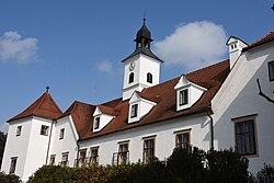
 Dornhofen Castle in Hart Dornhofen Castle in Hart | |
 Coat of arms Coat of arms | |
 Location within Graz-Umgebung district Location within Graz-Umgebung district | |
 | |
| Coordinates: 47°07′21″N 15°34′45″E / 47.12250°N 15.57917°E / 47.12250; 15.57917 | |
| Country | Austria |
| State | Styria |
| District | Graz-Umgebung |
| Area | |
| • Total | 15.84 km (6.12 sq mi) |
| Elevation | 426 m (1,398 ft) |
| Population | |
| • Total | 1,593 |
| • Density | 100/km (260/sq mi) |
| Time zone | UTC+1 (CET) |
| • Summer (DST) | UTC+2 (CEST) |
| Postal code | 8063 |
| Area code | 03117 |
| Vehicle registration | GU |
| Website | www.purgstall-eggersdorf. steiermark.at |
Hart-Purgstall is a former municipality in the district of Graz-Umgebung in the Austrian state of Styria. Since the 2015 Styria municipal structural reform, it is part of the municipality Eggersdorf bei Graz.
Population
| Year | Pop. | ±% |
|---|---|---|
| 1869 | 992 | — |
| 1880 | 978 | −1.4% |
| 1890 | 1,037 | +6.0% |
| 1900 | 1,026 | −1.1% |
| 1910 | 955 | −6.9% |
| 1923 | 946 | −0.9% |
| 1934 | 1,037 | +9.6% |
| 1939 | 1,026 | −1.1% |
| 1951 | 1,046 | +1.9% |
| 1961 | 1,026 | −1.9% |
| 1971 | 1,119 | +9.1% |
| 1981 | 1,243 | +11.1% |
| 1991 | 1,515 | +21.9% |
| 2001 | 1,653 | +9.1% |
References
- Statistik Austria - Bevölkerung zu Jahresbeginn 2002-2016 nach Gemeinden (Gebietsstand 1.1.2016) for Hart-Purgstall.
- Die neue Gemeindestruktur der Steiermark
This Styria location article is a stub. You can help Misplaced Pages by expanding it. |