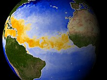
The main development region is the area of warm water in the Atlantic Ocean stretching from the west coast of northern Africa to the east coast of Central America and the Gulf Coast of the United States. Many tropical cyclones form within this area. Record-breaking sea surface temperatures in the main development region are on average hotter than any time on record.
Role in tropical cyclonegenesis

Tropical cyclone formation requires several factors, including: high humidity, low wind shear, and sufficiently warm sea surface temperatures. Regions of Earth's oceans with the required conditions are generally found between the latitudes of 8° and 20° from the Equator. An ocean temperature of at least 26.5 °C (79.7 °F) is normally considered the minimum to maintain a tropical cyclone. If water temperatures are lower, a system will most likely weaken. Conversely, higher water temperatures can enable a system to undergo rapid intensification.
In the Atlantic, the area between 10°N and 20°N spawns the most hurricanes in a given season because of the warmer temperatures. Hurricanes do not form outside this range because nearer to the equator the Coriolis effect is not strong enough to create the tight circulation needed, and farther north the temperatures are too cool. The waters are only at the necessary temperatures from July until mid-October. In the Atlantic this is the height of the season.
Since hurricanes rely on sea surface temperature, sometimes an initially active season becomes quiet later. This is because the hurricanes are so strong that they churn the waters and bring colder waters up from the deep. This creates an area of the sea the size of the hurricane, which has cooler waters, which can be 5–10 °C (9.0–18.0 °F) lower than before the hurricane. When a new hurricane moves over the cooler waters they have no fuel to continue to thrive, so they weaken or dissipate.
Historical trends
According to an Azores High hypothesis of geographer Kam-biu Liu, an anti-phase pattern is expected to exist between the Gulf of Mexico coast and the North American Atlantic coast. During the quiescent periods (3000–1400 BC, and 1000 AD to present), a more northeasterly position of the Azores High would result in more hurricanes being steered towards the Atlantic coast. During the hyperactive period (1400 BC to 1000 AD), more hurricanes were steered towards the Gulf coast as the Azores High was shifted to a more southwesterly position near the Caribbean. Such a displacement of the Azores High is consistent with paleoclimatic evidence that shows an abrupt onset of a drier climate in Haiti around 3200 years ago, and a change towards more humid conditions in the Great Plains during the late-Holocene as more moisture was pumped up the Mississippi Valley through the Gulf coast. Preliminary data from the northern Atlantic coast seem to support the Azores High hypothesis. A 3,000-year proxy record from a coastal lake in Cape Cod suggests that hurricane activity has increased significantly during the past 500–1,000 years, just as the Gulf coast was amid a quiescent period of the last millennium.
See also
References
- Goudzari, Sara (May 2, 2006). "Hurricane Alley Heats Up". LiveScience. Retrieved 9 September 2008.
- Jones, Benji (February 28, 2024). "This chart of ocean temperatures should really scare you". Vox Media. Retrieved May 31, 2024.
- Steve Graham; Holli Riebeek (1 November 2006). "Hurricanes: The Greatest Storms on Earth". NASA. Retrieved 29 July 2013.
- "Seeing into the Heart of a Hurricane". Earth Observatory. 12 October 2000.
- "NWS JetStream - Tropical Cyclone Introduction". National Weather Service.
- "Seeing into the Heart of a Hurricane". Earth Observatory. 12 October 2000.
- Liu, Kam-biu (1999). Millennial-scale variability in catastrophic hurricane landfalls along the Gulf of Mexico coast. 23d Conf. on Hurricanes and Tropical Meteorology. Dallas, TX: Amer. Meteor. Soc. pp. 374–377.
- Liu, Kam-biu; Fearn, Miriam L. (2000). "Reconstruction of Prehistoric Landfall Frequencies of Catastrophic Hurricanes in Northwestern Florida from Lake Sediment Records". Quaternary Research. 54 (2): 238–245. Bibcode:2000QuRes..54..238L. doi:10.1006/qres.2000.2166. S2CID 140723229.
- Higuera-Gundy, Antonia; et al. (1999). "A 10,300 C yr Record of Climate and Vegetation Change from Haiti". Quaternary Research. 52 (2): 159–170. Bibcode:1999QuRes..52..159H. doi:10.1006/qres.1999.2062. S2CID 129650957.
- Kam-biu Liu. "Millennial-scale Variability in Atlantic Hurricane Activities: Possible Links to the Hadley Circulation" (PDF). University of Louisiana.