| Ingdalen | |
|---|---|
| Village | |
  | |
| Coordinates: 63°27′35″N 9°54′33″E / 63.4596°N 09.9093°E / 63.4596; 09.9093 | |
| Country | Norway |
| Region | Central Norway |
| County | Trøndelag |
| District | Fosen |
| Municipality | Orkland |
| Elevation | 11 m (36 ft) |
| Time zone | UTC+01:00 (CET) |
| • Summer (DST) | UTC+02:00 (CEST) |
| Post Code | 7316 Lensvik |
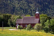
Ingdalen is a village in the municipality of Orkland in Trøndelag county, Norway. The village lies along the western shore of the Trondheimsfjord about 6.5 kilometres (4.0 mi) south of the villages of Lensvik and Selbekken. Ingdal Chapel is located in the village. The village was once a part of the municipality of Stadsbygd which included land on both sides of the fjord, but in 1964 the Ingdalen area was separated from Stadsbygd and merged into Agdenes which was on the same side of the fjord. The lake Øyangsvatnet lies about 10 kilometres (6.2 mi) west of the village.

References
- "Ingdalen, Agdenes (Trøndelag)". yr.no. Retrieved 2018-02-07.
- Store norske leksikon. "Agdenes" (in Norwegian). Retrieved 2011-01-21.
This Trøndelag location article is a stub. You can help Misplaced Pages by expanding it. |