Human settlement in England
| Ingrave | |
|---|---|
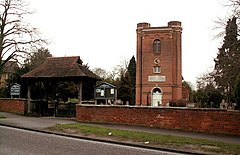
 St. Nicholas' church, Ingrave St. Nicholas' church, Ingrave | |
 | |
| OS grid reference | TQ623919 |
| Civil parish | |
| District | |
| Shire county | |
| Region | |
| Country | England |
| Sovereign state | United Kingdom |
| Post town | BRENTWOOD |
| Postcode district | CM13 |
| Dialling code | 01277 |
| Police | Essex |
| Fire | Essex |
| Ambulance | East of England |
| UK Parliament | |
| 51°36′07″N 0°20′42″E / 51.602°N 0.345°E / 51.602; 0.345 | |
Ingrave is a village and former civil parish, now in the parish of Herongate and Ingrave, in the Brentwood district in Essex, England. It is situated on and around the A128 road, 2 miles (3.2 km) southeast of the town of Brentwood. There is also the adjoining village of Herongate nearby. In 1931 the parish had a population of 692. On 1 January 1937 the parish was abolished and merged with Brentwood.
Name and history
Ingrave's name is derived from that of the original manor in this area, "Ging-Ralph" or "Ralph’s-ing". The manor was originally owned by the Mordaunt family but was acquired by the Petre family in 1573. The Petres built Thorndon Hall (now luxury apartments) on the site in 1770.
References
- "Population statistics Ingrave CP/AP through time". A Vision of Britain through Time. Retrieved 25 December 2021.
- "Relationships and changes Ingrave CP/AP through time". A Vision of Britain through Time. Retrieved 25 December 2021.
- "Herongate and Ingrave". Archived from the original on 26 September 2006. Retrieved 22 September 2008. Brentwood Council website
This Essex location article is a stub. You can help Misplaced Pages by expanding it. |