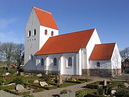
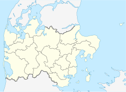
 The Church of Jegindø The Church of Jegindø | |
  | |
| Geography | |
|---|---|
| Location | Limfjord |
| Coordinates | 56°39′N 8°38′E / 56.650°N 8.633°E / 56.650; 8.633 |
| Area | 7.91 km (3.05 sq mi) |
| Administration | |
| Region | Central Denmark Region |
| Municipality | Struer Municipality |
| Demographics | |
| Population | 410 (2024) |
| Additional information | |
| Time zone | |
| • Summer (DST) | |
Jegindø, locally known as 'Jenø', is a Danish island in the western part of the Limfjord. The island is connected with the peninsula Thyholm via a dam. The main settlement is Jegind. Until 2007, the island was part of Thyholm Municipality, but now it is part of Struer Municipality. The island is 6 km long and 3 km across at its widest point. Jegindø covers an area of 7.91 km and has 410 inhabitants as of 2024. There are no forests, rivers, or lakes on Jegindø.
The island has a church, a harbour and a mission house. Commercially, the main industries are fisheries, the sale of fish and mussels, and farming.
References
- "Area and population. Regions and inhabited islands" (PDF). www.dst.dk. Retrieved 4 May 2024.
- ^ "Statistikbanken". www.statistikbanken.dk. Retrieved 4 May 2024.
- "Jegindø". Den Store Danske (in Danish). 9 March 2017. Retrieved 4 May 2024.
| Islands of Denmark
| ||
|---|---|---|
| Baltic Sea | ||
| Sydhavsøerne | ||
| Kattegat | ||
| South Funen Archipelago | ||
| Limfjorden | ||
| Øresund | ||
| Great Belt | ||
| Little Belt | ||
| Wadden Sea | ||
| Other islands |
| |
This article about an island of Denmark is a stub. You can help Misplaced Pages by expanding it. |