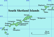

Jubilee Peak (61°8′S 54°2′W / 61.133°S 54.033°W / -61.133; -54.033) is a peak rising to about 500 metres (1,600 ft) at the north end of Clarence Island, west of Cape Lloyd, in the South Shetland Islands. Following the ascent of the peak by a JSEEIG party, February 2, 1977, it was named by the UK Antarctic Place-Names Committee in honor of the Silver Jubilee year of Her Majesty Queen Elizabeth II.
The team that carried out the first ascent was composed of Commander John Highton, Royal Navy (Leader), Captain Chris Hurran, Royal Engineers, and Lieutenant Mike Wimpenny, Royal Marines.
References
- "Jubilee Peak". Geographic Names Information System. United States Geological Survey, United States Department of the Interior. Retrieved 2013-04-08.
![]() This article incorporates public domain material from "Jubilee Peak". Geographic Names Information System. United States Geological Survey.
This article incorporates public domain material from "Jubilee Peak". Geographic Names Information System. United States Geological Survey.
This Clarence Island (South Shetland Islands) location article is a stub. You can help Misplaced Pages by expanding it. |