| Kamela | |
|---|---|
| Village | |
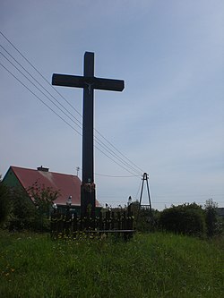
 Wayside cross in Kamela Wayside cross in Kamela | |
 | |
| Coordinates: 54°13′45″N 18°14′3″E / 54.22917°N 18.23417°E / 54.22917; 18.23417 | |
| Country | |
| Voivodeship | Pomeranian |
| County | Kartuzy |
| Gmina | Somonino |
| Population | 272 |
| Time zone | UTC+1 (CET) |
| • Summer (DST) | UTC+2 (CEST) |
| Vehicle registration | GKA |
Kamela is a village in the administrative district of Gmina Somonino, within Kartuzy County, Pomeranian Voivodeship, in northern Poland. It lies approximately 6 kilometres (4 mi) south-east of Somonino, 12 km (7 mi) south of Kartuzy, and 31 km (19 mi) south-west of the regional capital Gdańsk. It is located in the ethnocultural region of Kashubia in the historic region of Pomerania.
History
The village was founded after 1600.
During the German occupation of Poland (World War II), in 1939, some Poles from Kamela were among the victims of a massacre committed by the Germans in nearby Kaliska as part of the genocidal Intelligenzaktion campaign.
References
- "Central Statistical Office (GUS) - TERYT (National Register of Territorial Land Apportionment Journal)" (in Polish). 2008-06-01.
- Słownik geograficzny Królestwa Polskiego i innych krajów słowiańskich, Tom III (in Polish). Warsaw. 1882. p. 729.
{{cite book}}: CS1 maint: location missing publisher (link) - Wardzyńska, Maria (2009). Był rok 1939. Operacja niemieckiej policji bezpieczeństwa w Polsce. Intelligenzaktion (in Polish). Warsaw: IPN. p. 154.
This Kartuzy County location article is a stub. You can help Misplaced Pages by expanding it. |