| Kantang กันตัง | |
|---|---|
| District | |
 Kantang railway station, last stop of the Andaman Railway Line Kantang railway station, last stop of the Andaman Railway Line | |
 District location in Trang province District location in Trang province | |
| Coordinates: 7°24′20″N 99°30′55″E / 7.40556°N 99.51528°E / 7.40556; 99.51528 | |
| Country | Thailand |
| Province | Trang |
| Seat | Kantang |
| Area | |
| • Total | 612.7 km (236.6 sq mi) |
| Population | |
| • Total | 86,325 |
| • Density | 135.5/km (351/sq mi) |
| Time zone | UTC+7 (ICT) |
| Postal code | 92110 |
| Geocode | 9202 |
Kantang (Thai: กันตัง, pronounced [kān.tāŋ]) is a district (amphoe) in the western part of Trang province, Thailand.
History
Kantang was the original capital of Trang Province, at first in Khuan Thani, and then from 1893 to 1916 in Kantang itself. As the area was prone to flooding, the capital was moved inland to its present location. The city pillar shrine (lak mueang) of Trang is still at its original location at Khuan Thani.
Geography
Neighboring districts are (from the north clockwise): Sikao, Mueang Trang, and Yan Ta Khao of Trang Province. To the southwest is the Andaman Sea. The district is at the mouth of the Trang River.
Administration

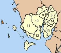
The district is divided into 14 sub-districts (tambons), which are further subdivided into 83 villages (mubans). The town (thesaban mueang) Kantang covers the entire tambon Kantang. There are 13 tambon administrative organizations (TAO) in the district.
| No. | Name | Thai | Villages | Pop. |
|---|---|---|---|---|
| 01. | Kantang | กันตัง | - | 13,225 |
| 02. | Khuan Thani | ควนธานี | 6 | 04,630 |
| 03. | Bang Mak | บางหมาก | 6 | 05,395 |
| 04. | Bang Pao | บางเป้า | 7 | 09,402 |
| 05. | Wang Won | วังวน | 5 | 03,991 |
| 06. | Kantang Tai | กันตังใต้ | 6 | 06,972 |
| 07. | Khok Yang | โคกยาง | 8 | 04,293 |
| 08. | Khlong Lu | คลองลุ | 7 | 04,069 |
| 09. | Yan Sue | ย่านซื่อ | 4 | 02,143 |
| 10. | Bo Nam Ron | บ่อน้ำร้อน | 9 | 09,039 |
| 11. | Bang Sak | บางสัก | 6 | 05,698 |
| 12. | Na Kluea | นาเกลือ | 6 | 04,299 |
| 13. | Ko Libong | เกาะลิบง | 8 | 06,843 |
| 14. | Khlong Chi Lom | คลองชีล้อม | 5 | 04,286 |
Economy
The Kantang District's chief industry is fishing. The industry is highly concentrated in few hands and has recently come under fire by international organisations for human trafficking, over-fishing, abuse of human rights, and outright murder. An Environmental Justice Foundation video went so far as to name Kanatang's Boonlarp Fishing Partnership, Ltd., as a particularly egregious bad actor.
References
- "Population statistics 2008". Department of Provincial Administration. Archived from the original on 2009-05-17.
- "EJF names Thai firm responsible for murder, slave labor". Undercurrent News. 2015-11-30. Retrieved 2 December 2015.
- Thailand's Seafood Slaves; Human Trafficking, Slavery and Murder in Kantang's Fishing Industry (PDF). London: Environmental Justice Foundation (EJF). 2015. ISBN 978-1-904523-37-6. Retrieved 2 December 2015.
- Thailand's Seafood Slaves (Video). YouTube. Environmental Justice Foundation (EJF). Archived from the original on 2021-12-15. Retrieved 19 August 2018.
External links
- amphoe.com (Thai)
| Districts of Trang | |
|---|---|
This Trang Province location article is a stub. You can help Misplaced Pages by expanding it. |