| Kasane | |
|---|---|
 Aerial view of Kasane with Chobe River Aerial view of Kasane with Chobe RiverTop right corner Kasane Airport | |
 Kasane Aerial View Kasane Aerial View | |
| Coordinates: 17°49′S 025°09′E / 17.817°S 25.150°E / -17.817; 25.150 | |
| Country | |
| District | Chobe District |
| Population | |
| • Total | 9,008 |
| Climate | BSh |
Kasane is a town in Botswana, close to Africa's 'Four Corners', where the borders of Botswana, Namibia, Zambia and Zimbabwe almost meet. The town is at the far northeastern corner of Botswana where it serves as the administrative center of the Chobe District. The population of Kasane was 9,244 at the 2011 census.
Kasane briefly obtained international fame as the location of the remarriage of Elizabeth Taylor to Richard Burton, in 1975.
Transport

The town lies on the south bank of the 200–300 metres (660–980 ft) wide Chobe River which forms the border with the extreme tip of Namibia's Caprivi Strip. The Namibian island of Impalila lies opposite the town on the north bank of the river, and there is a border crossing by passenger ferry to Namibia. About 8 kilometres (5 mi) to the east of Kasane is the village of Kazungula, where Botswana has 1.6 kilometres (1.0 mi) of frontage to the Zambezi river immediately below its confluence with the Chobe River. Here the Kazungula border post serves the Kazungula Bridge crossing to Kazungula in Zambia on the north bank of the Zambezi. Nearby a second border post serves the road into Zimbabwe which runs 70 kilometres (43 mi) east to Victoria Falls.
Kasane is at the northern end of the tarred highway from Francistown and Gaborone which is a regional artery between southern and central Africa particularly for trucks too heavy for the Victoria Falls Bridge's periodic weight restrictions. There is also a tarred road to the Namibian border 51 km west at Ngoma.
Kasane is at the north-eastern boundary of Chobe National Park and its road links make it a popular access point for tourists to the park as well as those including it in an itinerary taking in the Okavango Delta, the Caprivi Strip and Victoria Falls.
The town is served by Kasane Airport.
Amenities and social places
Kasane has a number of campsites and lodges (accommodations oriented towards the safari business). These lodges offer day trips into the Chobe National Park and Victoria Falls, and boat trips on the Chobe River.
Kasane has ABSA Bank, First National Bank, Stanbic and Standard Chartered Bank with ATM facility.
Climate
| Climate data for Kasane (1991–2020) | |||||||||||||
|---|---|---|---|---|---|---|---|---|---|---|---|---|---|
| Month | Jan | Feb | Mar | Apr | May | Jun | Jul | Aug | Sep | Oct | Nov | Dec | Year |
| Record high °C (°F) | 38.6 (101.5) |
39.9 (103.8) |
38.1 (100.6) |
35.8 (96.4) |
33.8 (92.8) |
36.7 (98.1) |
32.8 (91.0) |
36.5 (97.7) |
40.3 (104.5) |
41.0 (105.8) |
40.7 (105.3) |
39.5 (103.1) |
41.0 (105.8) |
| Mean daily maximum °C (°F) | 30.9 (87.6) |
30.6 (87.1) |
30.4 (86.7) |
30.4 (86.7) |
28.6 (83.5) |
26.4 (79.5) |
26.3 (79.3) |
29.7 (85.5) |
33.7 (92.7) |
35.8 (96.4) |
33.9 (93.0) |
31.5 (88.7) |
30.7 (87.3) |
| Daily mean °C (°F) | 25.3 (77.5) |
25.0 (77.0) |
24.7 (76.5) |
23.0 (73.4) |
20.1 (68.2) |
17.8 (64.0) |
17.5 (63.5) |
20.8 (69.4) |
24.7 (76.5) |
27.7 (81.9) |
27.1 (80.8) |
25.8 (78.4) |
23.2 (73.8) |
| Mean daily minimum °C (°F) | 19.5 (67.1) |
19.2 (66.6) |
18.5 (65.3) |
15.6 (60.1) |
11.5 (52.7) |
9.1 (48.4) |
8.5 (47.3) |
11.5 (52.7) |
15.6 (60.1) |
19.2 (66.6) |
20.1 (68.2) |
19.8 (67.6) |
15.6 (60.1) |
| Record low °C (°F) | 12.4 (54.3) |
14.0 (57.2) |
8.6 (47.5) |
4.4 (39.9) |
4.0 (39.2) |
0.5 (32.9) |
1.5 (34.7) |
1.2 (34.2) |
4.1 (39.4) |
10.0 (50.0) |
12.0 (53.6) |
11.8 (53.2) |
0.5 (32.9) |
| Average precipitation mm (inches) | 192.5 (7.58) |
139.4 (5.49) |
118.3 (4.66) |
51.5 (2.03) |
8.1 (0.32) |
8.3 (0.33) |
0.5 (0.02) |
4.5 (0.18) |
5.9 (0.23) |
24.3 (0.96) |
108.4 (4.27) |
151.5 (5.96) |
1,044.2 (41.11) |
| Average rainy days (≥ 10 mm) | 4 | 4 | 2 | 1 | 0 | 0 | 0 | 0 | 0 | 1 | 2 | 4 | 18 |
| Source 1: Météo Climat | |||||||||||||
| Source 2: World Meteorological Organization (rain days 1971-2000) | |||||||||||||
Gallery
-
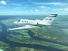
 Air Cessna Citation M2 over Kasane, Botswana
-
 Kasane Chobe Safari Lodge
-
 Downtown Kasane
-
 Kasane Airport
-
 Kasane street
-
 Kasane Airport
-
 Kasane road
-
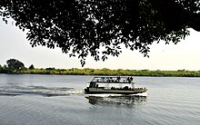
 Kasane: Chobe River boat cruise
-
 Air Botswana new Embraer E170 at Kasane International Airport
Notes
- "Population of Towns, Villages and Associated Localities" (PDF). 2001 Population and Housing Census. Gaborone: Central Statistics Office. April 2002. p. 141. Retrieved 5 September 2009.
- "2011 POPULATION AND HOUSING CENSUS" (PDF). 2011.
- Chris McIntyre (2010). Botswana. Bradt Travel Guides. pp. 193-193. ISBN 978-1-84162-308-5.
- "Kasane Lodges". Archived from the original on 2011-09-27. Retrieved 2020-02-14.
- "Météo Climat stats for Kasane 1991–2020". Météo Climat. Retrieved 15 October 2017.
- "Station Kasane" (in French). Meteo Climat. Retrieved 15 June 2016.
- "World Weather Information Service". World Meteorological Organization. Retrieved 16 August 2024.
External links
| 50 largest cities of Botswana by population | |||||||
|---|---|---|---|---|---|---|---|
| Italics indicate capitals of districts | |||||||
| Retrieved from 2011 Census | |||||||