| Kazusa Province上総国 | |||||||||
|---|---|---|---|---|---|---|---|---|---|
| Province of Japan | |||||||||
| 7th century–1868 | |||||||||
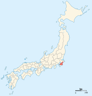
 Map of Japanese provinces (1868) with Kazusa Province highlighted | |||||||||
| Capital | Ichihara District | ||||||||
| History | |||||||||
| • Established | 7th century | ||||||||
| • Disestablished | 1868 | ||||||||
| |||||||||
| Today part of | Chiba Prefecture | ||||||||
Kazusa Province (上総国, Kazusa-no kuni) was a province of Japan in the area of modern Chiba Prefecture. The province was located in the middle of the Bōsō Peninsula, whose name takes its first kanji from the name of Awa Province and its second from Kazusa and Shimōsa provinces. Its abbreviated form name was Sōshū (総州) or Nansō (南総). The borders of Kazusa Province were defined by Shimōsa Province to the north, the Pacific Ocean to the east, Awa Province to the south, and Tokyo Bay to the west.

Kazusa was classified as one of the provinces of the Tōkaidō. Under the Engishiki classification system, Kazusa was ranked as a "great country" (大国) and a "far country" in relation to its distance from the capital (遠国). Along with Kōzuke and Hitachi, it was originally one of the provinces where an imperial prince was nominally assigned as governor.
History
Early history
Kazusa was originally part of a larger territory known as Fusa Province (総国, occasionally 捄国, Fusa-no-kuni), which was divided into "upper" and “lower” portions (i.e. Kazusa and Shimōsa) during the reign of Emperor Kōtoku (645–654). It was well known to the Imperial Court in Nara -period Japan for its fertile lands, and is mentioned in Nara period records as having supplied hemp to the Court. Kazusa was divided into 15 counties, of which the four counties comprising the district of Awa were separated in 718 into a separate province. The exact location of the capital of Kazusa is not precisely known, but is believed to have been somewhere within the borders of the modern city of Ichihara, Chiba. The ruins of the kokubun-ji, or provincial temple, of Kazusa has been located in the Sōza district of Ichihara. The kokubun-ji was first excavated in 1949, and is on a plateau 30 metres (98 ft) above the Yōrō River in close proximity to Tokyo Bay. The site is protected as a Designated Historic Site of Japan. However, the Ichinomiya of Kazusa Province is the Tamasaki Shrine in what is now the town of Ichinomiya, Chiba, on the opposite coast of the province.
During the Heian period, the province was divided into numerous shōen controlled by local samurai clans, primarily the Chiba clan, which sided with Minamoto no Yoritomo in the Genpei War. During the Kamakura period, much of the province was under the control of the Ashikaga clan. By the early Muromachi period, the area was a highly contested region highly fragmented by various samurai clans. However, by the Sengoku period, the Satomi clan had gained control over much of Awa, Kazusa and Shimōsa provinces.
The Satomi provided only lukewarm support to Toyotomi Hideyoshi during the Battle of Odawara against the Later Hōjō clan and were subsequently deprived of their holdings in Kazusa and Shimōsa. After the installation of Tokugawa Ieyasu in Edo, Kazusa became part of the Tokugawa clan holdings, and Tokugawa hereditary retainer Honda Tadakatsu was promoted to daimyō of Ōtaki Domain (50,000 koku).
Edo period
During the Edo period, several small domains were created within the borders of Kazusa, most of which continued to be retained as tenryō territory owned directly by the shōgun and administered by various hatamoto. The entire province had an assessed revenue of 425,080 koku.
Edo period Domains in Kazusa Province
| Domain | Daimyō | Dates | Revenue (koku) | Type |
|---|---|---|---|---|
| Kururi Domain (久留里藩) | Kuroda | 1659–1871 | 30,000 | fudai |
| Ōtaki Domain (大多喜藩) | Matsudaira (Nagasawa/Ōkōchi) | 1590–1871 | 20,000 | fudai |
| Iino Domain (飯野藩) | Hoshina | 1648–1871 | 20,000 | fudai |
| Sanuki Domain (佐貫藩) | Abe | 1590–1871 | 16,000 | fudai |
| Tsurumaki Domain (鶴牧藩) | Mizuno | 1827–1871 | 15,000 | fudai |
| Ichinomiya Domain (一宮藩) | Kanō | 1826–1871 | 13,000 | fudai |
| Jōzai Domain (請西藩) | Hayashi | 1825–1865 | 10,000 | fudai |
| Goi Domain (五井藩) | Arima | 1781–1842 | 10,000 | fudai |
| Kikuma Domain (菊間藩) | Mizuno | 1868–1871 | 23,700 | NA |
| Kokubo Domain (小久保藩) | Tanuma | 1868–1871 | 10,000 | NA |
| Ōami Domain (大網藩) | Yonekitsu | 1868–1871 | 10,000 | NA |
| Tsurumai Domain (鶴舞藩) | Inoue | 1868–1871 | 10,000 | NA |
| Matsuo Domain (松尾藩) | Ōta | 1868–1871 | 53,350 | NA |
| Sakurai Domain (桜井藩) | Matsudaira (Tatewaki) | 1868–1871 | 10,000 | NA |
Abolishment
Following the Boshin War, Jōzai Domain was abolished for its opposition to the Meiji Restoration, and six minor domains were created for daimyō dispossessed with the creation of Sunpu Domain for the ex-shōgun Tokugawa Yoshinobu. These various domains and tenryō territories were transformed into short-lived prefectures in July 1871 by the abolition of the han system, and the entire territory of Kazusa Province became part of the new Chiba Prefecture on June 15, 1873.
Historical districts
The area of former Kazusa Province was organized into nine districts by the Meiji period cadastral reforms, later reduced to five:
- Chiba Prefecture
- Amaha District (ja:天羽郡) - merged with Mōda and Sue Districts to become Kimitsu District (ja: 君津郡) on April 1, 1897
- Ichihara District (ja:市原郡) - dissolved
- Isumi District (ja: 夷隅郡)
- Kamihabu District (ja:上埴生郡) - merged with Nagara District to become Chōsei District (ja: 長生郡) on April 1, 1897
- Mōda District (ja:望陀郡) - merged with Amaha and Sue Districts to become Kimitsu District on April 1, 1897
- Musha District (ja:武射郡) - merged with Yamabe District to become Sanbu District (ja: 山武郡) on April 1, 1897
- Nagara District (ja:長柄郡) - merged with Kamihabu District to become Chōsei District on April 1, 1897
- Sue District (ja:周淮郡) - merged with Amaha and Mōda Districts to become Kimitsu District on April 1, 1897
- Yamabe District (ja:山辺郡) - merged with Musha District to become Sanbu District on April 1, 1897
Notes
- Nussbaum, Louis-Frédéric. (2005). "Kazusa" in Japan Encyclopedia, p. 502, p. 502, at Google Books.
- ^ "上総国" [Kazusa Province]. Nihon Daihyakka Zensho (Nipponika) (in Japanese). Tokyo: Shogakukan. 2012. OCLC 153301537. Archived from the original on 2007-08-25. Retrieved 2012-09-04.
- "上総国分寺跡" [Remains of Kazusa Kokubun-ji]. Nihon Rekishi Chimei Taikei (in Japanese). Tokyo: Shogakukan. 2012. OCLC 173191044. dlc 2009238904. Archived from the original on 2007-08-25. Retrieved 2012-11-21.
- よみがえる天平の甍:国指定史跡上総国分尼寺跡 [Restoring the Tempyō Tiles: The Kazusa Kokubunniji National Historical Site] (PDF) (in Japanese). Ichihara, Chiba Prefecture, Japan: Kazusa Kokubunniji National Historical Site Exhibition Hall. c. 1998. Retrieved Nov 21, 2012.
References
- Nussbaum, Louis-Frédéric and Käthe Roth. (2005). Japan encyclopedia. Cambridge: Harvard University Press. ISBN 978-0-674-01753-5; OCLC 58053128
- Papinot, Edmond. (1910). Historical and Geographic Dictionary of Japan. Tokyo: Librarie Sansaisha. OCLC 77691250
External links
![]() Media related to Kazusa Province at Wikimedia Commons
Media related to Kazusa Province at Wikimedia Commons
| Former provinces of Japan (List) | |
|---|---|
| Kinai | |
| Tōkaidō | |
| Tōsandō | |
| Hokurikudō | |
| San'indō | |
| San'yōdō | |
| Nankaidō | |
| Saikaidō | |
| Hokkaidō 1869– | |
| Pre-Taihō Code provinces | |
Source: Nussbaum, Louis-Frédéric. (2005). "Provinces and prefectures" in Japan Encyclopedia, p. 780, p. 780, at Google Books; excerpt,
| |