Town in New South Wales, Australia
| Kiora New South Wales | |||||||||||||||
|---|---|---|---|---|---|---|---|---|---|---|---|---|---|---|---|
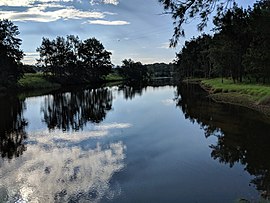
 Deua or Moruya River at Kiora Bridge Deua or Moruya River at Kiora Bridge | |||||||||||||||
 | |||||||||||||||
| Coordinates | 35°54′21″S 150°00′51″E / 35.90583°S 150.01417°E / -35.90583; 150.01417 | ||||||||||||||
| Population | 54 (2016 census) | ||||||||||||||
| Postcode(s) | 2537 | ||||||||||||||
| Location | 11 km (7 mi) W of Moruya | ||||||||||||||
| LGA(s) | Eurobodalla Shire | ||||||||||||||
| Region | South Coast | ||||||||||||||
| County | Dampier | ||||||||||||||
| Parish | Mogendoura | ||||||||||||||
| State electorate(s) | Bega | ||||||||||||||
| Federal division(s) | Gilmore | ||||||||||||||
| |||||||||||||||
Kiora is a locality in the Eurobodalla Shire, New South Wales, Australia. It is located about 11 km west of Moruya on the road to Araluen at the point where the Deua River becomes estuarine and changes its name to the Moruya River. At the 2016 census, it had a population of 54. Its name derives from the Kiora House, which belonged to John Hawdon. It had a public school from 1868 to 1928.
References
- ^ Australian Bureau of Statistics (27 June 2017). "Kiora". 2016 Census QuickStats. Retrieved 31 January 2018.

- ^ "Kiora". Geographical Names Register (GNR) of NSW. Geographical Names Board of New South Wales. Retrieved 31 January 2018.

- "Kiora". OpenStreetMap. Retrieved 31 January 2018.
- "KIORA". Sydney Morning Herald. 6 November 1935. Retrieved 20 February 2022.
- "Kiora Public School in the School history database search". New South Wales Department of Education. Retrieved 31 January 2018.
This South Coast geography article is a stub. You can help Misplaced Pages by expanding it. |