| This article needs additional citations for verification. Please help improve this article by adding citations to reliable sources. Unsourced material may be challenged and removed. Find sources: "Kolokani" – news · newspapers · books · scholar · JSTOR (January 2024) (Learn how and when to remove this message) |
| Kolokani | |
|---|---|
| Commune and town | |
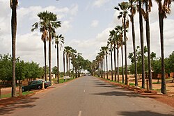
 National Route 1 in Kolokani National Route 1 in Kolokani | |
 | |
| Coordinates: 13°35′27″N 8°02′03″W / 13.59083°N 8.03417°W / 13.59083; -8.03417 | |
| Country | |
| Region | Koulikoro Region |
| Cercle | Kolokani Cercle |
| Population | |
| • Total | 57,307 |
| Time zone | UTC+0 (GMT) |
Kolokani is a town of approximately 57,307 inhabitants in Mali's Koulikoro Region.
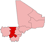
It is the capital of the Cercle of Kolokani, which consists of 10 rural communes (Didieni, Guihoyo, Kolokani, Massantola, Nonkon, Nossombougou, Ouolodo, Sagabala, Sebecoro and Tioribougou). The cercle of Kolokani has an area of 14,380 km² and a population of 163,886 inhabitants.
Residents of Kolokani include the iconic musician Mariam Bagayogo, Rokia Traoré and noted bògòlanfini artist Nakunte Diarra.
See also
References
- "Collections - National Museum of African Art". africa.si.edu. Archived from the original on 18 September 2018. Retrieved 18 September 2018.
This Koulikoro Region location article is a stub. You can help Misplaced Pages by expanding it. |
