| This article needs additional citations for verification. Please help improve this article by adding citations to reliable sources. Unsourced material may be challenged and removed. Find sources: "Koundara Prefecture" – news · newspapers · books · scholar · JSTOR (November 2018) (Learn how and when to remove this message) |
| Koundara Prefecture | |
|---|---|
| Prefecture | |
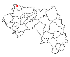
 Location of Koundara Prefecture and seat in Guinea. Location of Koundara Prefecture and seat in Guinea. | |
| Country | |
| Region | Boké Region |
| Capital | Koundara |
| Area | |
| • Total | 5,238 km (2,022 sq mi) |
| Population | |
| • Total | 130,205 |
| • Density | 25/km (64/sq mi) |
| Time zone | UTC+0 (Guinea Standard Time) |
Koundara is a prefecture located in the Boké Region of Guinea. The capital is Koundara. The prefecture covers an area of 5,238 km (2,022 sq mi) and has a population of 130,205.
Capital
Koundara town is served by Sambailo Airport. As of 2014 it had a population of 27,433 people.
Sub-prefectures
The prefecture is divided administratively into 7 sub-prefectures:
| Prefectures of Guinea | ||
|---|---|---|
| Boké Region | ||
| Conakry Region | ||
| Faranah Region | ||
| Kankan Region | ||
| Kindia Region | ||
| Labé Region | ||
| Mamou Region | ||
| Nzérékoré Region | ||
References
- "Guinea". Institut National de la Statistique, Guinea, accessed via Geohive. Archived from the original on 24 November 2015. Retrieved 27 August 2014.
12°29′02″N 13°18′08″W / 12.48389°N 13.30222°W / 12.48389; -13.30222
This Guinea location article is a stub. You can help Misplaced Pages by expanding it. |