| Kuala Belait Port | |
|---|---|
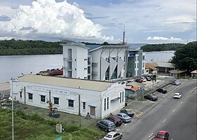
 Kuala Belait Port in 2020 Kuala Belait Port in 2020 | |
| Click on the map for a fullscreen view | |
| Location | |
| Country | Brunei |
| Location | Kuala Belait, Belait |
| Coordinates | 4°34′55″N 114°11′26″E / 4.5818942°N 114.1904280°E / 4.5818942; 114.1904280 |
| Details | |
| Operated by | Maritime and Port Authority Brunei Darussalam |
| Draft depth | 8 ft (2.4 m) |
| Statistics | |
| Website mpabd | |
The Kuala Belait Port (Malay: Pelabuhan Kuala Belait), also known as Kuala Belait Wharf, is a port operated by both the Brunei Shell Petroleum (BSP) and Maritime and Port Authority Brunei Darussalam (MPABD). The port can only accommodate low-draught ships. It is one of the only three existing ports in the country.
Geography
The port sits at the east bank of the Belait River, opposite of Sungai Teraban and not far from the District's capital Kuala Belait. It has a shallow depth of 8 ft (2.4 m). Kuala Belait port is also one of the closest sea facility from Sarawak, Malaysia. It can also be noted that only Muara Port and Kuala Belait Port provided shipping to Hong Kong, Singapore and other parts of Asia. The location allowed ships to have full access to the South China Sea.
History
The Royal Brunei Navy held an Open Ship & Career Exhibition at the port on 15 December 2007. On 30 September 2021, the MPABD building in the government wharf was lit up blue in conjunction to the World Maritime Day.
Facilities
There are several designated areas and facilities within the two different sections of the port:
Brunei Shell Petroleum wharf
- A 90 ft (27 m) long pier
- Five 25 t (25 long tons; 28 short tons) cranes
- A 22 t (22 long tons; 24 short tons) derrick
Government wharf
- A 328 ft (100 m) long wharf
- A 5 t (4.9 long tons; 5.5 short tons) crane
- Warehouse and storage facilities
References
- The Report: Brunei Darussalam 2007. Oxford Business Group. p. 96. ISBN 978-1-902339-75-7.
- Brunei Customs, Trade Regulations and Procedures Handbook Volume 1 Strategic Information and Basic Regulations. IBP Inc. p. 96. ISBN 978-1-4387-0631-3.
- Page, Kogan (2003). Asia and Pacific Review 2003/04: The Economic and Business Report. Kogan Page Publishers. p. 39. ISBN 978-0-7494-4063-3.
- Page, Kogan (2003). Asia and Pacific Review 2003/04: The Economic and Business Report. Kogan Page Publishers. p. 222. ISBN 978-0-7494-4063-3.
- "Immigration - Statistic and Control Posts". www.immigration.gov.bn. Retrieved 25 May 2022.
- ^ Office, United States Naval Oceanographic. Sailing Directions for Soenda Strait and the Western and Northeast Coasts of Borneo and Offlying Islands. pp. 220a.
- Salkin, David M. (25 July 2017). Dangerous Ground: The Team Book Five. Simon and Schuster. p. 93. ISBN 978-1-68261-441-9.
- Viator, Aleks. SAILING VESSEL DESTINATIONS IN HUMAN CIVILIZATIONS. Lulu.com. ISBN 978-1-304-06715-9.
- Davidson, Paul; Ciambella, Franca (14 June 2012). Investment in South East Asia. Routledge. ISBN 978-1-136-39177-4.
- "KUALA BELAIT BREAKWATER EA". iec-brunei.com. Retrieved 25 May 2022.
- "Royal Brunei Navy in Kuala Belait". House of Gembo. 15 December 2007. Retrieved 25 May 2022.
- "Maritime buildings turn blue to honour seafarers » Borneo Bulletin Online". Maritime buildings turn blue to honour seafarers. 2 October 2021. Retrieved 25 May 2022.