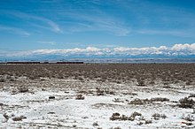

The Kura-Aras Lowland, Kura-Aras Depression or Kura-Aras Basin (Azerbaijani: Kür-Araz ovalığı) is a vast depression in central-southern Azerbaijan defined by the valleys of the Kura River and Aras River. It is situated by the West shore of the Caspian Sea and is part of the Aral-Caspian Depression. It is delimited by the Greater Caucasus from the North, Lesser Caucasus from the West and the Talysh Mountains from the South. The name is derived from the names of the two rivers in the area: the Kura and the Aras.
See also
- Kura–Araxes culture or Kur–Araz culture, Bronze Age culture from the region
- Trans-Caucasus
References
- The name of Aras may also be variously transliterates as Araz, Arax, or Araxes.
- Profile of Azerbaijan Archived 2011-06-06 at the Wayback Machine, a 2003 World Bank document
- "Azerbaijan - History, People, & Facts". britannica.com. Archived from the original on 10 March 2018. Retrieved 24 April 2018.
Further reading
- Akif A. Alizadeh, Ibrahim S. Guliyev, Fakhraddin A. Kadirov, Lev V. Eppelbaum (Jun 17, 2016). Geosciences of Azerbaijan. Springer. p. 17. ISBN 978-3-319-27395-2.
{{cite book}}: CS1 maint: multiple names: authors list (link)
41°10′00″N 45°50′00″E / 41.1667°N 45.8333°E / 41.1667; 45.8333
This Azerbaijan location article is a stub. You can help Misplaced Pages by expanding it. |