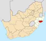
Place in KwaZulu-Natal, South Africa
| Kwambonambi | |
|---|---|
  | |
| Coordinates: 28°36′00″S 32°05′00″E / 28.6°S 32.083333°E / -28.6; 32.083333 | |
| Country | South Africa |
| Province | KwaZulu-Natal |
| District | King Cetshwayo |
| Municipality | uMfolozi |
| Area | |
| • Total | 3.27 km (1.26 sq mi) |
| Population | |
| • Total | 2,872 |
| • Density | 880/km (2,300/sq mi) |
| Racial makeup (2011) | |
| • Black African | 82.6% |
| • Coloured | 0.6% |
| • Indian/Asian | 0.8% |
| • White | 15.6% |
| • Other | 0.4% |
| First languages (2011) | |
| • Zulu | 77.1% |
| • English | 11.2% |
| • Afrikaans | 8.7% |
| • Other | 2.9% |
| Time zone | UTC+2 (SAST) |
| PO box | 3915 |
| Area code | 035 |
Kwambonambi is a town in King Cetshwayo District Municipality in the KwaZulu-Natal province of South Africa.
Village, centre of sugar and timber areas, 29 km north-east of Empangeni, 30 km south-west of Mtubatuba and 30 km north of Richards Bay. Zulu, ‘place of the Mbonambi’, a tribe which lived there, the name means ‘ill-omen’.
References
- ^ "Sub Place Kwambonambi". Census 2011.
- "Dictionary of Southern African Place Names (Public Domain)". Human Science Research Council. p. 267.
| Municipalities and communities of King Cetshwayo District Municipality, KwaZulu-Natal | ||
|---|---|---|
| District seat: Richards Bay | ||
| uMhlathuze |  | |
| uMlalazi | ||
| Nkandla | ||
| Mbonambi | ||
| Ntambanana | ||
| Mthonjaneni | ||
This KwaZulu-Natal location article is a stub. You can help Misplaced Pages by expanding it. |