| La Londe-les-Maures | |
|---|---|
| Commune | |
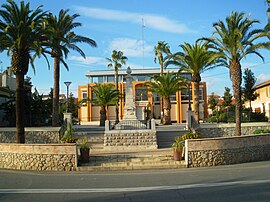
 The town hall of La Londe-les-Maures The town hall of La Londe-les-Maures | |
 Coat of arms Coat of arms | |
| Location of La Londe-les-Maures | |
  | |
| Coordinates: 43°08′17″N 6°14′04″E / 43.1381°N 6.2344°E / 43.1381; 6.2344 | |
| Country | France |
| Region | Provence-Alpes-Côte d'Azur |
| Department | Var |
| Arrondissement | Toulon |
| Canton | La Crau |
| Government | |
| • Mayor (2023–2026) | François De Canson (DVD) |
| Area | 79.29 km (30.61 sq mi) |
| Population | 11,010 |
| • Density | 140/km (360/sq mi) |
| Time zone | UTC+01:00 (CET) |
| • Summer (DST) | UTC+02:00 (CEST) |
| INSEE/Postal code | 83071 /83250 |
| Elevation | 0–601 m (0–1,972 ft) |
| French Land Register data, which excludes lakes, ponds, glaciers > 1 km (0.386 sq mi or 247 acres) and river estuaries. | |
La Londe-les-Maures (French pronunciation: [la lɔ̃d le mɔʁ]; Occitan: La Lònda dei Mauras) is a commune in the Var department in the Provence-Alpes-Côte d'Azur region in southeastern France.
Population
| Graphs are unavailable due to technical issues. Updates on reimplementing the Graph extension, which will be known as the Chart extension, can be found on Phabricator and on MediaWiki.org. |
| Year | Pop. | ±% p.a. |
|---|---|---|
| 1968 | 3,956 | — |
| 1975 | 3,937 | −0.07% |
| 1982 | 5,184 | +4.01% |
| 1990 | 7,151 | +4.10% |
| 1999 | 8,749 | +2.27% |
| 2007 | 10,043 | +1.74% |
| 2012 | 9,116 | −1.92% |
| 2017 | 10,297 | +2.47% |
| Source: INSEE | ||
Points of interest
See also
References
- "Répertoire national des élus: les maires" (in French). data.gouv.fr, Plateforme ouverte des données publiques françaises. 6 June 2023.
- "Populations de référence 2022" (in French). The National Institute of Statistics and Economic Studies. 19 December 2024.
- Population en historique depuis 1968, INSEE
This Var geographical article is a stub. You can help Misplaced Pages by expanding it. |