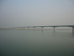
| Lalon Shah Bridge লালন শাহ সেতু | |
|---|---|
 | |
| Coordinates | 24°03′54″N 89°01′45″E / 24.065°N 89.029167°E / 24.065; 89.029167 |
| Crosses | Padma |
| Locale | Pabna and Kushtia |
| Characteristics | |
| Design | Box girder bridge |
| Material | Prestressed concrete |
| Total length | 1.8 km (1.1 mi) |
| Width | 18.10 m (59.4 ft) |
| History | |
| Designer | Rendel Palmer and Tritton |
| Constructed by | China Major Bridge Engineering Company Limited |
| Opened | 18 May 2004 |
| Statistics | |
| Toll | Yes |
| Location | |
Lalon Shah Bridge (Bengali: লালন শাহ সেতু), locally known as Pakshey Bridge, is a road bridge in Bangladesh over the river Padma. The bridge connects Ishwardi Upazila of Pabna on the east, and Bheramara Upazila of Kushtia on the west. It was constructed by China Major Bridge Engineering Co. Ltd and was opened in 2004. The bridge is named after early 19th-century mystic poet Lalon Shah of Chhewuriya, Kushtia District.

The bridge is 1,800 metres (5,900 ft) long and is the third longest road bridge of the country, after the Padma Multipurpose Bridge and Bangabandhu Bridge. It is on the N704. It provides important road connection to Mongla port of Khulna District in the south from Rajshahi division and Rangpur division, the northern part of Bangladesh.
It is situated parallel to and south (downstream) of Hardinge Bridge.
References
- ^ "Lalon Shah Bridge". Structurae. 22 July 2014. Retrieved 17 October 2014.
- "Lalon Shah Bridge". Heidelberg cement. Retrieved 15 August 2018.
- ^ হোসেন, আনোয়ার (5 June 2022). পদ্মার বুকে সবচেয়ে বড় সেতু. Prothomalo (in Bengali). Retrieved 8 September 2024.
| Bangladesh articles | |||||||||||||||
|---|---|---|---|---|---|---|---|---|---|---|---|---|---|---|---|
| History |
| ||||||||||||||
| Geography | |||||||||||||||
| Politics |
| ||||||||||||||
| Economy |
| ||||||||||||||
| Society |
| ||||||||||||||
| Bridges in Bangladesh | |
|---|---|
24°03′55″N 89°01′48″E / 24.0654°N 89.0300°E / 24.0654; 89.0300
This article about a bridge in Bangladesh is a stub. You can help Misplaced Pages by expanding it. |
- Road bridges in Bangladesh
- Bridges completed in 2004
- Bridges over the Ganges
- Pabna District
- Kushtia District
- Road bridges in Kushtia District
- 2004 establishments in Bangladesh
- Tourist attractions in Kushtia District
- Asian bridge (structure) stubs
- Bangladeshi building and structure stubs
- Bangladesh transport stubs