| This article needs additional citations for verification. Please help improve this article by adding citations to reliable sources. Unsourced material may be challenged and removed. Find sources: "List of airports in the Spratly Islands" – news · newspapers · books · scholar · JSTOR (December 2016) (Learn how and when to remove this message) |
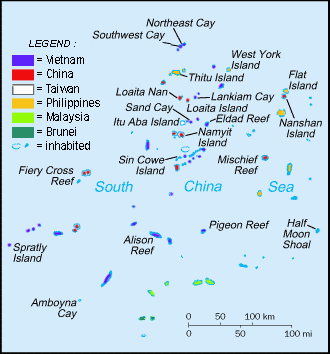
This is a list of airports in the Spratly Islands in the South China Sea.
Airports
| Location | Occupied by | Name | Code | Built | Length | Notes |
|---|---|---|---|---|---|---|
| Taiping Island | Taiping Island Airport | RCSP | 2007 | 1,200 m (est.) | Military use only. No refueling facilities. | |
| Swallow Reef (Layang-Layang) | Layang-Layang Airport | LAC | 1995 | 1,367 m | Dual-use concrete airport. | |
| Fiery Cross Reef | Yongshu Airport | AG 4553 | 2016 | 3,300 m (est.) | Dual-use concrete airport. | |
| Subi Reef | Zhubi Airport | 2016 | 3,000 m (est.) | Dual-use concrete airport. | ||
| Mischief Reef | Meiji Airport | 2016 | 2,700 m (est.) | Dual-use concrete airport. | ||
| Thitu Island (Pag-asa) | Rancudo Airfield | RPPN | 1978 | 1,300 m (est.) | Dual-use concrete airport. | |
| Spratly Island (Trường Sa) | Trường Sa Airport | 1976–77 | 1,200 m (est.) | Military use only. Extended from 600 m to 1,200 m in 2016. |
Location

References
- The Taiping Island Airport was completed in December 2007, ("MND admits strategic value of Spratly airstrip." Taipei Times. 6 January 2006. p. 2 (MND is the ROC Ministry of National Defense)), and a C-130 Hercules transporter airplane first landed on the island on 21 January 2008.
- Bong Lozada (18 June 2014). "Air Force to repair Pagasa Island airstrip". Philippine Daily Inquirer. Retrieved 2016-12-26.
- ^ "Vietnam Responds". Center for Strategic and International Studies. 2016-12-01. Retrieved 2016-12-26.
Further reading
- James Hardy (London) and Sean O'Connor (Indiana) (20 Nov 2014). "China building airstrip-capable island on Fiery Cross Reef". IHS Jane's 360. Jane's Defence Weekly.
| Spratly Islands | |
|---|---|
| Confrontations | |
| Regions | |
| Occupied features | |
| Unoccupied features | |
| Related articles | |
| South China Sea | |||||||||||||||||
|---|---|---|---|---|---|---|---|---|---|---|---|---|---|---|---|---|---|
| Pratas Island | |||||||||||||||||
| Paracel Islands |
| ||||||||||||||||
| Northeastern SCS | |||||||||||||||||
| Spratly Islands |
| ||||||||||||||||
| Southeastern SCS | |||||||||||||||||
| Southern SCS | |||||||||||||||||
| Tudjuh Archipelago | |||||||||||||||||
| History |
| ||||||||||||||||
| Transport |
| ||||||||||||||||
