| Luhe | |
|---|---|
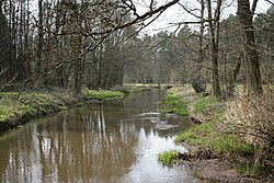
 The River Luhe near Wohlenbüttel The River Luhe near Wohlenbüttel | |
| Location | |
| Country | Germany |
| State | Lower Saxony |
| Reference no. | DE: 5948 |
| Physical characteristics | |
| Source | |
| • location | Bispingen |
| • coordinates | 53°04′01″N 9°58′49″E / 53.066806°N 9.980139°E / 53.066806; 9.980139 |
| • elevation | 80 m (260 ft) |
| Mouth | |
| • location | Ilmenau near Stöckte [ca; de] |
| • coordinates | 53°23′04″N 10°12′20″E / 53.384306°N 10.2054861°E / 53.384306; 10.2054861 |
| • elevation | 7 m (23 ft) |
| Length | 56.1 km (34.9 mi) |
| Basin size | 476 km (184 sq mi) |
| Basin features | |
| Progression | Ilmenau→ Elbe→ North Sea |
| Landmarks |
|
| Tributaries | |
| • left | Brunau, Schwinde, Garlstorfer Aue |
| • right | Lopau |
The Luhe is a river in Lower Saxony, Germany. It runs through the Lüneburg Heath, and discharges into the Ilmenau and thus is part of the Elbe river system.
The entire catchment area of the Luhe has been heavily populated since the New Stone Age as evinced by sites like the monuments at Soderstorf and the Oldendorfer Totenstatt grave sites. At the height of the present-day town of Winsen (Luhe), a bridge over the Luhe was controlled by Winsen Castle [de] from the 13th century onwards.
See also
References
- ^ Environmental map service of Lower Saxony (Umweltkartendienst des Niedersächsischen Ministeriums für Umwelt, Energie und Klimaschutz)
This article related to a river in Lower Saxony is a stub. You can help Misplaced Pages by expanding it. |