Neighbourhood in Visakhapatnam, Andhra Pradesh, India
| Mangamaripeta Madhura Mangamaripeta | |
|---|---|
| Neighbourhood | |
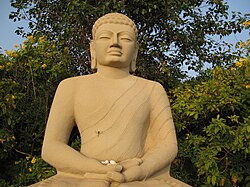
 Buddha statue at Thotlakonda Buddha statue at Thotlakonda | |
 | |
| Coordinates: 17°50′00″N 83°24′47″E / 17.833198°N 83.412932°E / 17.833198; 83.412932 | |
| Country | |
| State | Andhra Pradesh |
| District | Visakhapatnam |
| Government | |
| • Body | Greater Visakhapatnam Municipal Corporation |
| Languages | |
| • Official | Telugu |
| Time zone | UTC+5:30 (IST) |
| PIN | 531163 |
| Vehicle registration | AP-31 |
Mangamaripeta (Telugu: మంగమరి పేట) is a seaside place with a watersport beach in Visakhapatnam, India. It is believed that the region was under the kingdom of Kalingas. Later, the beach served as the promotional centre of Buddhism. The beach is popular for Thotlakonda, a hill embracing a Buddhist complex, located at an elevation of 128 m. above sea level. Mangamaripeta is accessible by Bus Routes 900k or 900T from the Dwaraka bus station via Siripuram, Appugarh and Gitam.
Landmarks and attractions
Among its landmarks is a natural stone arch. Other landmarks include the Thotlakonda Buddhist complex, a seaview park, Mangamaripeta Beach and the Mangamaripeta Bridge.
References
- "about". thehindu. 10 October 2017. Retrieved 21 September 2017.
- "Natural arch at Mangamaripeta cries for attention". The Hindu. 13 November 2020. Retrieved 13 February 2021.
This article about a location in Visakhapatnam is a stub. You can help Misplaced Pages by expanding it. |