Place in Oregon, United States
| Marylhurst, Oregon | |
|---|---|
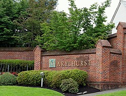
 Sign at entrance to community Sign at entrance to community | |
  | |
| Coordinates: 45°24′04″N 122°39′04″W / 45.40111°N 122.65111°W / 45.40111; -122.65111 | |
| Country | United States |
| State | Oregon |
| County | Clackamas |
| Elevation | 151 ft (46 m) |
| Time zone | UTC-8 (Pacific (PST)) |
| • Summer (DST) | UTC-7 (PDT) |
| GNIS feature ID | 1158626 |
Marylhurst, Oregon is the location of a U.S. Post Office, ZIP Code 97036, in southern Lake Oswego, Oregon on the campus of Marylhurst University (closed in 2018).
Marylhurst, more commonly accepted, is the name of a neighborhood within the city of Lake Oswego, OR and is also the name of a residential development across from the campus, which officially is part of the Glenmorrie neighborhood of Lake Oswego, Oregon. It is located approximately eight miles south of Portland on Oregon Route 43 near the Willamette River.
References
- ^ U.S. Geological Survey Geographic Names Information System: Marylhurst, Oregon
- MARYLHURST — Post Office™
- City of Lake Oswego Neighborhood Map
| Municipalities and communities of Clackamas County, Oregon, United States | ||
|---|---|---|
| County seat: Oregon City | ||
| Cities |  | |
| Hamlets | ||
| CDPs | ||
| Other communities |
| |
| Indian reservation | ||
| Footnotes | ‡This populated place also has portions in an adjacent county or counties | |
This Clackamas County, Oregon state location article is a stub. You can help Misplaced Pages by expanding it. |