| Moengotapoe | |
|---|---|
| Resort | |
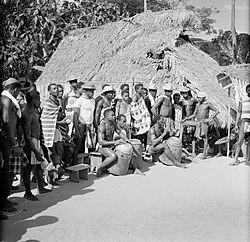
 Moengotapoe (1955) Moengotapoe (1955) | |
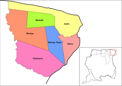
 Map showing the resorts of Marowijne District. Moengotapoe Map showing the resorts of Marowijne District. Moengotapoe | |
| Country | |
| District | Marowijne District |
| Area | |
| • Total | 455 km (176 sq mi) |
| Elevation | 6 m (20 ft) |
| Population | |
| • Total | 579 |
| • Density | 1.3/km (3.3/sq mi) |
| Time zone | UTC-3 (AST) |
Moengotapoe is a resort in Suriname, located in the Marowijne District. Its population at the 2012 census was 579.
The village of Moengotapoe was not spared during the Surinamese Interior War, because it was the home of Brunswijk at the time. On 22 July 1986, Brunswijk captured the military post near Stolkertsijver and opened fire on the army barracks in Albina. The National Army responded by destroying the temple in Moengotapoe, and capturing all males present. The women and children fled the village.
References
- ^ "Resorts of Suriname. 2012 census" (PDF). Spang Staging. Retrieved 14 May 2020.
- "Leger Suriname zoekt gijzelaars". Reformatorisch Dagblad via Digibron (in Dutch). 26 July 1986. Retrieved 17 May 2020.
- "The Kingdom Of The Netherlands In The Caribbean. Suriname 1954 – 2004: Kroniek van een illusie". Rozenberg Quarterly (in Dutch). Retrieved 14 May 2020.
| Resorts and places in Marowijne District, Suriname | |
|---|---|
| Albina | |
| Galibi | |
| Moengo | |
| Moengotapoe |
|
| Patamacca | |
| Wanhatti | |
| Italic denotes the capital | |
5°34′48″N 54°14′38″W / 5.58000°N 54.24389°W / 5.58000; -54.24389
This Suriname location article is a stub. You can help Misplaced Pages by expanding it. |
