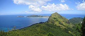
| Mont Mokoto | |
|---|---|
 | |
| Highest point | |
| Elevation | 426 m (1,398 ft) |
| Prominence | 170 m (560 ft) |
| Coordinates | 23°7′39″S 134°59′9″W / 23.12750°S 134.98583°W / -23.12750; -134.98583 |
| Geography | |
 | |
Mont Mokoto is a mountain located in the South Pacific, on the island of Mangareva. It has an elevation of 426 metres (1,398 ft) above sea level and is north of the town of Rikitea.
References
- ^ "Mokoto, French Polynesia". Peakbagger.com. Retrieved 2021-11-22.
- Stanley, David (1999). South Pacific Handbook. David Stanley. p. 266. ISBN 978-1-56691-172-6.
This French Polynesia-related geography article is a stub. You can help Misplaced Pages by expanding it. |