| Montijo District | |
|---|---|
| District | |
 | |
 | |
| Coordinates: 7°59′32″N 81°3′16″W / 7.99222°N 81.05444°W / 7.99222; -81.05444 | |
| Country | |
| Province | Veraguas Province |
| Capital | Montijo |
| Area | |
| • Total | 300 sq mi (780 km) |
| Population | |
| • Total | 7,060 |
| • Density | 23/sq mi (9.1/km) |
| official estimate | |
| Time zone | UTC-5 (ETZ) |

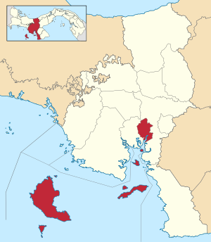
Montijo District is a district (distrito) of Veraguas Province in Panama. The population according to the 2000 census was 12,211; the latest official estimate (for 2019) is 7,060. The district covers a total area of 780 km. It includes all of the offshore islands of Coiba National Park, the largest of which are Coiba and Jicarón. The capital lies at the town of Montijo. The district includes the Gulf of Montijo and the islands in it.
Administrative divisions
Montijo District is divided administratively into the following corregimientos:
References
- ^ Instituto Nacional de Estadística y Censo, Panama.
- ^ "Districts of Panama". Statoids. Retrieved April 13, 2009.
External links
| Bocas del Toro Province | |
|---|---|
| Chiriquí Province | |
| Coclé Province | |
| Colón Province | |
| Darién Province | |
| Herrera Province | |
| Los Santos Province | |
| Panamá Province | |
| Veraguas Province | |
| West Panamá Province | |
This article about the geography of Veraguas Province is a stub. You can help Misplaced Pages by expanding it. |
