| Morondava District | |
|---|---|
| District | |
 Morondava Morondava | |
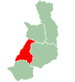
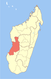
 Location in Menabe region Location in Menabe region | |
| Coordinates: 20°31′S 44°22′E / 20.517°S 44.367°E / -20.517; 44.367 | |
| Country | |
| Region | Menabe |
| Capital | Morondava |
| Area | |
| • Total | 5,691 km (2,197 sq mi) |
| Population | |
| • Total | 157,596 |
| • Density | 28/km (72/sq mi) |
| Time zone | UTC3 (EAT) |
| Postal code | 619 |
Morondava District is a district in the Menabe region in eastern Madagascar. Its capital is Morondava. The district has an area of 5,691 km (2,197 sq mi), and the estimated population in 2020 was 157,596.
Municipalities
The district is further divided into six municipalities:
Roads
- RN 34 to Ivato, Ambositra and Antsirabe.
- RN 8 to Belo-sur-Tsiribihina.
Airports
Rivers
Nature
- Tsingy de Bemaraha Strict Nature Reserve
- Andranomena Reserve
- Kirindy Forest
- Avenue of the Baobabs, 20 km north of Morondava.
Religion
- Roman Catholic Diocese (Cathedral of Mary Queen of the World).
- Fiangonana Jesosy Mamonjy Morondava
- FJKM - Fiangonan'i Jesoa Kristy eto Madagasikara (Church of Jesus Christ in Madagascar)
See also
- Betania, a beach village in Morondava district.
References
- Morondava autrement
- REPOBLIKAN'I MADAGASIKARA:Tanindrazana – Fahafahana – Fandrosoana (PDF). MINISTERE DE L’AGRICULTURE, DE L’ELEVAGE ET DE LA PECHE. October 2007. pp. 42–44. Archived from the original (PDF) on 2018-06-12. Retrieved 2018-06-09.
- "Madagascar: Administrative Division". citypopulation. Retrieved 10 June 2018.
- "Madagascar: Administrative Division". citypopulation. Retrieved 10 June 2018.
| Capital: Morondava | ||
| Belo sur Tsiribihina (16) (608) |  | |
| Mahabo (12) (615) | ||
| Manja (7) (616) | ||
| Miandrivazo (16) (617) | ||
| Morondava (6) (619) | ||
| 5 districts; 57 communes | ||
This Menabe location article is a stub. You can help Misplaced Pages by expanding it. |