| This article relies largely or entirely on a single source. Relevant discussion may be found on the talk page. Please help improve this article by introducing citations to additional sources. Find sources: "Mount Gimber" – news · newspapers · books · scholar · JSTOR (October 2024) |
| Mount Gimber | |
|---|---|
| Highest point | |
| Coordinates | 72°1′S 102°0′W / 72.017°S 102.000°W / -72.017; -102.000 |
| Geography | |
| Location | Thurston Island, Ellsworth Land, Antarctica |
| Parent range | Walker Mountains |


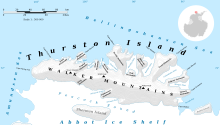
Mount Gimber (72°1′S 102°0′W / 72.017°S 102.000°W / -72.017; -102.000) is an ice-covered mountain 0.5 nautical miles (0.93 km) southeast of Landfall Peak in the extreme west part of Thurston Island, Ellsworth Land, Antarctica. It was named by the Advisory Committee on Antarctic Names (US-ACAN) after Commander H.M.S. Gimber, the captain of the destroyer Brownson in the Eastern Group of U.S. Navy Operation Highjump, 1946–47.
See also
Maps
- Thurston Island – Jones Mountains. 1:500000 Antarctica Sketch Map. US Geological Survey, 1967.
- Antarctic Digital Database (ADD). Scale 1:250000 topographic map of Antarctica. Scientific Committee on Antarctic Research (SCAR), 1993–2016.
References
Portal:| Antarctica | ||||||||
|---|---|---|---|---|---|---|---|---|
| Geography |
|  | ||||||
| History | ||||||||
| Politics | ||||||||
| Society | ||||||||
| Famous explorers | ||||||||
This Thurston Island location article is a stub. You can help Misplaced Pages by expanding it. |