 NOAA 2 lifts off NOAA 2 lifts off | |
| Mission type | Weather |
|---|---|
| Operator | NOAA |
| COSPAR ID | 1972-082A |
| SATCAT no. | 6235 |
| Mission duration | 2 years and 3 months |
| Spacecraft properties | |
| Manufacturer | RCA Astrospace |
| Launch mass | 306 kilograms (675 lb) |
| Start of mission | |
| Launch date | October 15, 1972, 17:17 (1972-10-15UTC17:17Z) UTC |
| Rocket | Delta-300 |
| Launch site | Vandenberg SLC-2W |
| End of mission | |
| Disposal | Decommissioned |
| Deactivated | January 30, 1975 (1975-01-31) |
| Orbital parameters | |
| Reference system | Geocentric |
| Regime | Low Earth Sun-synchronous |
| Eccentricity | 0.00032 |
| Perigee altitude | 1,448 kilometers (900 mi) |
| Apogee altitude | 1,453 kilometers (903 mi) |
| Inclination | 101.8° |
| Period | 114.9 minutes |
| Epoch | October 15, 1972 |
| Instruments | |
| SPM, SR, VHRR, VTPR | |
| ITOS← ITOS-BITOS-E → | |
NOAA-2, also known as ITOS-D was a weather satellite operated by the National Oceanic and Atmospheric Administration (NOAA). It was part of a series of satellites called ITOS, or improved TIROS. NOAA-2 was launched on a Delta rocket on October 15, 1972. The launch carried one other satellite: AMSAT-OSCAR 6.
Mission of NOAA-2
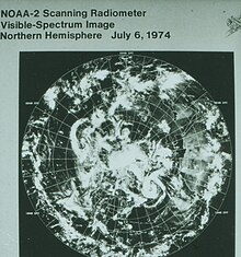
NOAA 2 was the first in a series of reconfigured ITOS-M satellites launched with new meteorological sensors on board to expand the operational capability of the ITOS system. NOAA 2 was not equipped with conventional TV cameras. It was the first operational weather satellite to rely solely upon radiometric imaging to obtain cloud cover data. The primary objective of NOAA 2 was to provide global daytime and nighttime direct readout real-time cloud cover data on a daily basis. The Sun-synchronous spacecraft was also capable of supplying global atmospheric temperature soundings and very high resolution infrared cloudcover data for selected areas in either a direct readout or a tape-recorder mode. A secondary objective was to obtain global solar-proton flux data on a real-time daily basis.

The primary sensors consisted of Very High Resolution Radiometer (VHRR), a Vertical Temperature Profile Radiometer (VTPR), and a Scanning Radiometer (SR). The VHRR, VTPR, and SR were mounted on the satellite baseplate with their optical axes directed vertically earthward.
The nearly cubical spacecraft measured 1 by 1 by 1.2 meters (3.3 ft × 3.3 ft × 3.9 ft). The satellite was equipped with three curved solar panels that were folded during launch and deployed after orbit was achieved. Each panel measured over 4.2 meters (14 ft) in length when unfolded and was covered with approximately 3,500 solar cells measuring 2 by 2 centimeters (0.79 in × 0.79 in). The NOAA 2 dynamics and attitude control system maintained desired spacecraft orientation through gyroscopic principles incorporated into the satellite design. Earth orientation of the satellite body was maintained by taking advantage of the precession induced from a momentum flywheel so that the satellite body precession rate of one revolution per orbit provided the desired Earth-looking attitude. Minor adjustments in attitude and orientation were made by means of magnetic coils and by varying the speed of the momentum flywheel.
The spacecraft operated satisfactorily until March 18, 1974, when VTPR failed. NOAA 2 was then placed in a marginal standby mode from March 19 to July 1, 1974. It was then used as the operational NOAA satellite until October 16, 1974, when it was again placed in a marginal standby mode. The spacecraft was deactivated on January 30, 1975.
Current status
The satellite's ITOS imaging system has been heard transmitting a sync signal containing no image, on March 13, 2021, by Scott Tilley, confirmed shortly after by Derek OK9SGC and again later by Derek on September 25, 2022.
As of January 11, 2023 the satellite continues to broadcast this sync signal, and software made by Alexandre Rouma ON5RYZ/KE8SUI and Jacopo IU1QPT is available for decoding.
References
- ^ "NASA/NSSDC NOAA-2 spacecraft details". Retrieved June 7, 2018.
 This article incorporates text from this source, which is in the public domain.
- "NOAA 2 Satellite Position". karhukoti.com. Retrieved October 26, 2022.
- ^ McDowell, Jonathan. "Launch Log". Jonathan's Space Page. Retrieved June 7, 2018.
- "WMO OSCAR | Satellite: NOAA-2". space.oscar.wmo.int. Retrieved March 20, 2024.
- Wade, Mark. "ITOS". Encyclopedia Astronautica. Archived from the original on September 13, 2008. Retrieved October 20, 2008.
- @coastal8049 (March 13, 2021). "The NOAA 2 spacecraft is tumbling with a period of about 88.6s. The on/off duty cycle is asymmetrical with it on for about ~28s and off for ~61s" (Tweet) – via Twitter.
- "NOAA-2 returning from the dead". sgcderek.github.io. March 15, 2021. Retrieved September 26, 2022.
- @dereksgc (September 25, 2022). "Strong signal received from NOAA-2 just now on 80cm dish" (Tweet) – via Twitter.
- "NOAA ITOS High Resolution Picture Transmission (HRPT) - Signal Identification Wiki". www.sigidwiki.com. Retrieved February 22, 2023.
- "NOAA-2 satellite reception and decoding | Antro di Jacopo". www.a-centauri.com. Retrieved February 22, 2023.
External links
| TIROS satellites | ||
|---|---|---|
| TIROS |  | |
| TOS | ||
| ITOS | ||
| TIROS-N | ||
| Adv. TIROS-N | ||