Human settlement in England
| Nackington | |
|---|---|
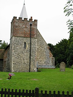
 St Mary's church St Mary's church | |
 | |
| Civil parish | |
| District | |
| Shire county | |
| Region | |
| Country | England |
| Sovereign state | United Kingdom |
| Post town | Canterbury |
| Postcode district | CT4 |
| Police | Kent |
| Fire | Kent |
| Ambulance | South East Coast |
| 51°14′59″N 1°05′20″E / 51.2497°N 1.0888°E / 51.2497; 1.0888 | |
Nackington is an English village and former civil parish, now in the parish of Lower Hardres and Nackington, south of Canterbury in the Canterbury district, in the county of Kent. The 12th century church is dedicated to St Mary. In 1931 the parish had a population of 80.
History
On 1 April 1934 the parish of was merged into "Lower Hardres" and on 1 April 2019 the new parish was renamed to "Lower Hardres and Nackington".
References
- "St Mary, Nackington". Church of England.
- "Population Statistics Nackington AP/CP through time". Vision of Britain. Retrieved 15 May 2019.
- "Relationships and changes Nackington AP/CP through time". A Vision of Britain through Time. Retrieved 15 May 2019.
- "The Canterbury City Council (Reorganisation of Community Governance) Order 2018" (PDF). Local Government Boundary Commission for England. Retrieved 15 May 2019.
External links
![]() Media related to Nackington at Wikimedia Commons
Media related to Nackington at Wikimedia Commons
This Kent location article is a stub. You can help Misplaced Pages by expanding it. |
