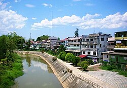
| Ngao River | |
|---|---|
 Ngao River in Ngao town Ngao River in Ngao town | |
| Native name | แม่น้ำงาว (Thai) |
| Location | |
| Country | Thailand |
| State | Phayao Province, Lampang Province, Phrae Province |
| City | Ngao town |
| Physical characteristics | |
| Source | |
| • location | Phi Pan Nam Range, Phayao Province |
| • elevation | 1,267 m (4,157 ft) |
| Mouth | Yom River |
| • location | Kaeng Suea Ten area, Song District, Phrae Province |
| • coordinates | 18°35′54″N 100°8′53″E / 18.59833°N 100.14806°E / 18.59833; 100.14806 |
| • elevation | 195 m (640 ft) |
| Length | 98 km (61 mi) |
| Basin size | 1,800 km (690 sq mi) |
The Ngao River (Thai: แม่น้ำงาว, RTGS: Maenam Ngao, pronounced [mɛ̂ː.náːm ŋāːw]; Northern Thai: น้ำแม่งาว, pronounced [náːm mɛ̂ː.ŋāːw]) is a river of Thailand with its source in the Phi Pan Nam Range. It is a tributary of the Yom River, part of the Chao Phraya River basin.
The Ngao in this basin should not be confused with the Ngao River that is a tributary of the Yuam River (แม่น้ำยวม), part of the Salween basin, located to the west.
See also
References
- Mae Nam Yom
- "Mae Ngao National Park". Archived from the original on 2012-04-06. Retrieved 2012-05-05.
This article related to a river in Thailand is a stub. You can help Misplaced Pages by expanding it. |