| Parts of this article (those related to census data) need to be updated. Please help update this article to reflect recent events or newly available information. (October 2015) |
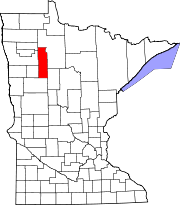
North Clearwater is an unorganized territory in Clearwater County, Minnesota, United States. The population was 70 at the time of the 2020 census.
Geography
According to the United States Census Bureau, the unorganized territory has a total area of 191.9 square miles (497.1 km), of which 187.1 square miles (484.7 km) is land and 4.8 square miles (12.4 km) (2.50%) is water.
This unorganized territory falls completely within the boundaries of the Red Lake Indian Reservation.
Demographics
As of the census of 2020, there were 70 people and 20 households residing in the unorganized territory. The population density was 0.4 inhabitants per square mile (0.15/km). There were 25 housing units. The racial makeup of the unorganized territory was 4.28% White, 1.43% Asian, and 91.43% Native American or Alaska Native. 2.86% reported two or more races. Hispanic or Latino of any race were 4.29% of the population.
There were 20 households, out of which none reported having children under the age of 18 living with them. 55% of responders reported as having been widowed. 45% reported as having never married. 55% of households had someone living alone who was 65 years of age or older. The average household size was unreported.
In the unorganized territory the population was relatively concentrated, with 45% of responders being from 55 to 59 years old, and 55% who were 65 years of age or older. The median age was unreported. All responders were male.
The median income for a household in the unorganized territory was unreported. The per capita income for the unorganized territory was $9,389. 45% were reported as living below the poverty line, none of whom were over 64.
References
- "North Clearwater, UT; Clearwater County; Minnesota". United States Census Bureau. Retrieved 2023-05-26.
| Municipalities and communities of Clearwater County, Minnesota, United States | ||
|---|---|---|
| County seat: Bagley | ||
| Cities |  | |
| Townships | ||
| CDPs | ||
| Unorganized territories | ||
| Unincorporated communities | ||
| Indian reservations | ||
| Ghost town | ||
| Footnotes | ‡This populated place also has portions in an adjacent county or counties | |
47°55′33″N 95°23′14″W / 47.92583°N 95.38722°W / 47.92583; -95.38722
Categories: