Village in Szabolcs-Szatmár-Bereg, Hungary
| Nyírbogát | |
|---|---|
| Village | |
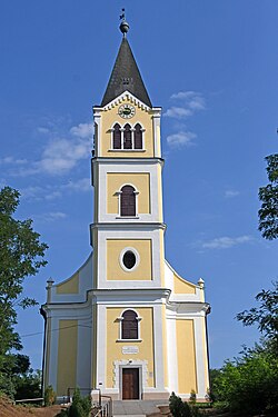
 Reformed church in Nyírbogát, Reformed church in Nyírbogát, | |
 Coat of arms Coat of arms | |
| Country | |
| County | Szabolcs-Szatmár-Bereg |
| Area | |
| • Total | 55.36 km (21.37 sq mi) |
| Population | |
| • Total | 3,105 |
| • Density | 56.1/km (145/sq mi) |
| Time zone | UTC+1 (CET) |
| • Summer (DST) | UTC+2 (CEST) |
| Postal code | 4361 |
| Area code | 42 |

Nyírbogát is a village in Szabolcs-Szatmár-Bereg county, in the Northern Great Plain region of eastern Hungary.
Geography
It covers an area of 55.36 km (21 sq mi) and, in 2015, had a population of 3105.
History
The village has been the site of human habitation since the stone age. Its name first appears in writing in 1310, as the name of a local noble. Its earliest landowners were members of the Kállay family, who held titles to the village's land until the end of the 1300s.
Demographics
As of 2022, the village is 94% Hungarian, 2.8% Gypsy, and 1.1% of non-European origin. The population is 34.6% Reformed, 20.3% Greek Catholic, 10% Roman Catholic, and 3.8% nondenominational.
References
- ^ Gazetteer of Hungary, 1 January 2015. Hungarian Central Statistical Office. 03/09/2015
- "Magyarország helységnévtára". www.ksh.hu. Retrieved 9 June 2024.
47°48′N 22°04′E / 47.800°N 22.067°E / 47.800; 22.067
This Szabolcs-Szatmár-Bereg location article is a stub. You can help Misplaced Pages by expanding it. |

