| This article does not cite any sources. Please help improve this article by adding citations to reliable sources. Unsourced material may be challenged and removed. Find sources: "Oost-Watergraafsmeer" – news · newspapers · books · scholar · JSTOR (February 2022) (Learn how and when to remove this message) |
You can help expand this article with text translated from the corresponding article in Dutch. Click for important translation instructions.
|
| Oost-Watergraafsmeer | |
|---|---|
 The Oosterpark The Oosterpark | |
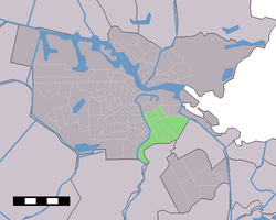
 Map of Amsterdam where Oost-Watergraafsmeer is green Map of Amsterdam where Oost-Watergraafsmeer is green | |
 | |
| Coordinates: 52°20′52.98000″N 4°55′51.19399″E / 52.3480500000°N 4.9308872194°E / 52.3480500000; 4.9308872194 | |
| Country | Netherlands |
Oost-Watergraafsmeer was a stadsdeel (borough) of Amsterdam until 2010. It bordered Diemen, Duivendrecht, and the boroughs Amsterdam-Centrum, Oud-Zuid, Zeeburg, and Zuideramstel. The Watergraafsmeer part of the borough is a polder.
Located in Oost/Watergraafsmeer:
References
External links
This North Holland location article is a stub. You can help Misplaced Pages by expanding it. |