| Opoj | |
|---|---|
| Municipality | |
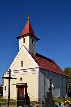
 Church in Opoj Church in Opoj | |
  | |
| Coordinates: 48°18′N 17°39′E / 48.300°N 17.650°E / 48.300; 17.650 | |
| Country | Slovakia |
| Region | Trnava |
| District | Trnava |
| Area | |
| • Total | 4.61 km (1.78 sq mi) |
| Elevation | 131 m (430 ft) |
| Population | |
| • Total | 1,277 |
| Postal code | 919 32 |
| Area code | +421 33 |
| Car plate | TT |
| Website | www.opoj.sk |
Opoj (Hungarian: Apaj) is a village and municipality of Trnava District in the Trnava region of Slovakia.
Etymology
The name comes from the Slovak opojiť: to saturate, to soak (with water). Opoj: literally "a land area that is saturated with water" (wet meadow). 1266 Opoy.
References
- "Počet obyvateľov podľa pohlavia - obce (ročne)". www.statistics.sk (in Slovak). Statistical Office of the Slovak Republic. 2022-03-31. Retrieved 2022-03-31.
- ^ "Hustota obyvateľstva - obce [om7014rr_ukaz: Rozloha (Štvorcový meter)]". www.statistics.sk (in Slovak). Statistical Office of the Slovak Republic. 2022-03-31. Retrieved 2022-03-31.
- ^ "Základná charakteristika". www.statistics.sk (in Slovak). Statistical Office of the Slovak Republic. 2015-04-17. Retrieved 2022-03-31.
- ^ "Hustota obyvateľstva - obce". www.statistics.sk (in Slovak). Statistical Office of the Slovak Republic. 2022-03-31. Retrieved 2022-03-31.
- ^ Krajčovič, Rudolf (2013). "Z lexiky stredovekej slovenčiny s výkladmi názvov obcí a miest (47)". Kultúra slova (in Slovak) (6). Martin: Vydavateľstvo Matice slovenskej: 331.
External links
- http://en.e-obce.sk/obec/opoj/opoj.html
- http://www.statistics.sk/mosmis/eng/run.html
- Official web page (in Slovak)
This Trnava Region geography article is a stub. You can help Misplaced Pages by expanding it. |