You can help expand this article with text translated from the corresponding article in Portuguese. Click for important translation instructions.
|

| Pão de Açúcar | |
|---|---|
 Flag Flag Coat of arms Coat of arms | |
 | |
| Established | 3 March 1854 |
| Area | |
| • Total | 658.955 km (254.424 sq mi) |
| Population | |
| • Total | 24,351 |
| • Density | 37/km (96/sq mi) |
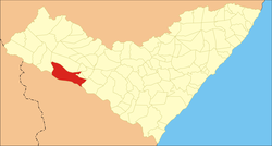
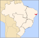
09°44′52″S 37°26′13″W / 9.74778°S 37.43694°W / -9.74778; -37.43694 Pão de Açúcar is a municipality in the Brazilian state of Alagoas. Its population is 24,351 (2020) and its area is 659 km².
Geography
Climate
| Climate data for Pão de Açúcar, Alagoas (1981–2010, extremes 1977–present) | |||||||||||||
|---|---|---|---|---|---|---|---|---|---|---|---|---|---|
| Month | Jan | Feb | Mar | Apr | May | Jun | Jul | Aug | Sep | Oct | Nov | Dec | Year |
| Record high °C (°F) | 40.8 (105.4) |
40.2 (104.4) |
40.0 (104.0) |
40.4 (104.7) |
39.6 (103.3) |
36.8 (98.2) |
34.6 (94.3) |
35.8 (96.4) |
37.8 (100.0) |
40.8 (105.4) |
44.2 (111.6) |
42.2 (108.0) |
44.2 (111.6) |
| Mean daily maximum °C (°F) | 36.3 (97.3) |
36.2 (97.2) |
36.0 (96.8) |
34.4 (93.9) |
31.9 (89.4) |
29.6 (85.3) |
29.2 (84.6) |
29.9 (85.8) |
32.3 (90.1) |
34.7 (94.5) |
36.1 (97.0) |
36.7 (98.1) |
33.6 (92.5) |
| Daily mean °C (°F) | 29.4 (84.9) |
29.4 (84.9) |
29.3 (84.7) |
28.4 (83.1) |
26.7 (80.1) |
25.0 (77.0) |
24.4 (75.9) |
24.5 (76.1) |
26.1 (79.0) |
28.1 (82.6) |
29.3 (84.7) |
29.7 (85.5) |
27.5 (81.5) |
| Mean daily minimum °C (°F) | 23.8 (74.8) |
23.9 (75.0) |
24.1 (75.4) |
23.7 (74.7) |
22.6 (72.7) |
21.4 (70.5) |
20.6 (69.1) |
20.1 (68.2) |
20.8 (69.4) |
22.0 (71.6) |
22.9 (73.2) |
23.8 (74.8) |
22.5 (72.5) |
| Record low °C (°F) | 18.1 (64.6) |
10.3 (50.5) |
18.8 (65.8) |
17.9 (64.2) |
16.3 (61.3) |
14.8 (58.6) |
15.2 (59.4) |
12.3 (54.1) |
16.7 (62.1) |
18.0 (64.4) |
18.1 (64.6) |
18.7 (65.7) |
10.3 (50.5) |
| Average precipitation mm (inches) | 56.5 (2.22) |
36.7 (1.44) |
50.9 (2.00) |
59.8 (2.35) |
86.5 (3.41) |
90.0 (3.54) |
81.5 (3.21) |
56.1 (2.21) |
24.6 (0.97) |
19.3 (0.76) |
12.0 (0.47) |
12.8 (0.50) |
586.7 (23.10) |
| Average precipitation days (≥ 1.0 mm) | 4 | 4 | 5 | 7 | 13 | 14 | 13 | 11 | 5 | 2 | 2 | 2 | 82 |
| Average relative humidity (%) | 60.0 | 62.3 | 65.3 | 70.5 | 78.8 | 83.4 | 83.6 | 79.9 | 71.5 | 63.2 | 58.8 | 57.7 | 69.6 |
| Mean monthly sunshine hours | 269.0 | 233.8 | 247.4 | 226.7 | 192.7 | 162.5 | 175.6 | 195.7 | 239.4 | 276.2 | 284.5 | 275.2 | 2,778.7 |
| Source 1: Instituto Nacional de Meteorologia | |||||||||||||
| Source 2: Meteo Climat (record highs and lows) | |||||||||||||
See also
References
- IBGE 2020
- "Normais Climatológicas Do Brasil 1981–2010" (in Portuguese). Instituto Nacional de Meteorologia. Retrieved 25 October 2018.
- "Station Pao de Acucar" (in French). Meteo Climat. Retrieved 25 October 2018.
| Capital: Maceió | ||
| Arapiraca |  | |
| Palmeira dos Índios | ||
| Traipu | ||
| Litoral Norte Alagoano | ||
| Maceió | ||
| Mata Alagoana | ||
| Penedo | ||
| São Miguel dos Campos | ||
| Serrana dos Quilombos | ||
| Alagoana do Sertão do São Francisco | ||
| Batalha | ||
| Santana do Ipanema | ||
| Serrana do Sertão Alagoano | ||
This Alagoas, Brazil location article is a stub. You can help Misplaced Pages by expanding it. |