| This article needs additional citations for verification. Please help improve this article by adding citations to reliable sources. Unsourced material may be challenged and removed. Find sources: "Pasaco" – news · newspapers · books · scholar · JSTOR (October 2009) (Learn how and when to remove this message) |
| Pasaco | |
|---|---|
 | |
| Coordinates: 13°59′N 90°12′W / 13.983°N 90.200°W / 13.983; -90.200 | |
| Country | |
| Department | |
| Climate | Aw |
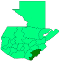
Pasaco (Spanish pronunciation: [paˈsako]) is a municipality in the Jutiapa department of Guatemala, located near the Pacific Ocean on the Border with El Salvador.
History
It was originally formed when a group of Aztecs broke off at the arrival of Hernán Cortés, and went further south into what is now Guatemala (then Coahtemalan, or The Land of Abundance, in a Mayan dialect). They united with some groups of Indians, pushing others into what is now El Salvador, recognizing Cortés as a villain, not Quetzalcoatl, or the great white God returned, as the Náhuatl, or Aztec leadership supposed at that time. Unfortunately, they sat up near the ocean, and were soon spotted by Pedro de Alvarado, who Hernán Cortés had sent to destroy the cultures and civilizations further south. After planting poisonous sticks in the ground, which were nearly always fatal, and about what Pedro de Alvarado complains about loudly in his diary, the Spanish departed southward, and Pasaco, or rather Paxa at that time, moved somewhat inland. After being flooded out, they moved location to Pasaco, or literally, “goodbye Paxa” where the town remains to this day.
Transportation
Until recently there were no cars nor transportation to Pasaco, and the people had to walk about 5 km inland to reach the town, although there is now a paved road into town, and even a small public library.
References
13°59′N 90°12′W / 13.983°N 90.200°W / 13.983; -90.200
| Capital: Jutiapa | ||
| Municipalities |  | |
This article related to indigenous Mesoamerican culture is a stub. You can help Misplaced Pages by expanding it. |