You can help expand this article with text translated from the corresponding article in Vietnamese. (March 2009) Click for important translation instructions.
|
| Phù Cát district Huyện Phù Cát | |
|---|---|
| District | |
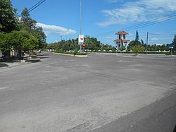
 A corner of Ngo May town in Phù Cát District A corner of Ngo May town in Phù Cát District | |
 | |
| Coordinates: 13°59′N 109°3′E / 13.983°N 109.050°E / 13.983; 109.050 | |
| Country | |
| Region | South Central Coast |
| Province | Bình Định province |
| Capital | Ngô Mây |
| Area | |
| • Total | 680 km (260 sq mi) |
| Population | |
| • Total | 257,890 |
| • Density | 380/km (980/sq mi) |
| Time zone | UTC+7 (Indochina Time) |
Phù Cát is a district (huyện) of Bình Định province in the South Central Coast region of Vietnam.
The district capital lies at Ngô Mây.
The district is also home to Phu Cat Airport.
References
- Bình Định Statistics Office (2010): Bình Định Statistical Yearbook 2009. Statistical Publishing House, Hanoi
- "Districts of Vietnam". Statoids. Retrieved March 13, 2009.
| Districts of the South Central Coast of Vietnam | ||
|---|---|---|
| Da Nang city |  | |
| Bình Định province | ||
| Bình Thuận province | ||
| Khánh Hòa province |
| |
| Ninh Thuận province | ||
| Phú Yên province | ||
| Quảng Nam province | ||
| Quảng Ngãi province | ||
| denotes provincial seat. / Sovereignty over the Hoàng Sa and Trường Sa archipelagoes is disputed as of 17 January 2025. | ||
This article about a location in Bình Định province, Vietnam is a stub. You can help Misplaced Pages by expanding it. |