| Native name: Île Philemon | |
|---|---|
 | |
 | |
| Etymology | Philemon Wright |
| Geography | |
| Location | Ottawa River |
| Coordinates | 45°25′24″N 75°43′01″W / 45.42333°N 75.71694°W / 45.42333; -75.71694 |
| Length | 823 m (2700 ft) |
| Width | 305 m (1001 ft) |
| Highest elevation | 56 m (184 ft) |
| Administration | |
| Canada | |
| Province | Quebec |
| Census Division | Gatineau |
| District | Hull–Wright District |
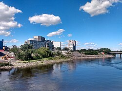
Philemon Island (French: Île Philemon) is a former artificial island in the Hull sector of Gatineau, Quebec, Canada. Currently part of the mainland, it was once an island in the Ottawa River, separated from the mainland by a timber slide for nearly 150 years. It was part of an archipelago of islands below Chaudière Falls, known as the "Chaudière Islands" that contain Victoria Island, Chaudière Island, Amelia Island and Albert Island. It is accessible via Rue Eddy and the Portage Bridge.
History
Originally known as the "Peninsular Village", it became an island in 1829 when Ruggles Wright (son of Philemon, for whom the island is named) constructed a timber slide between the island and Hull in order to bypass the falls. The channel was used as a timber slide (known as the "Hull Crib Slide") until 1929.
Businessman Ezra Butler Eddy bought the island in 1870 and built a large sawmill there. The E. B. Eddy Company owned several industrial buildings on the island, which were taken over by Domtar in 1998 when it bought E. B. Eddy.
The channel between the island and the Hull mainland was filled in with "indifferent rubble" during the early 1970s.
In the late 2010s, the O Condominiums were built on the former island, as part of the larger Zibi development, an ongoing redevelopment project of the Chaudière Islands.
References
- "Museological plan : Philemon Wright National Fluvial Museum". issuu.
- GeoOttawa
- "Île Philemon". Geographical Names Data Base. Natural Resources Canada.
- ^ "Domtar Lands Redevelopment Project: Cultural Heritage Impact Statement Chaudière and Albert Islands Sector, City of Ottawa" (PDF). City of Ottawa.
- "A Glimpse of Chaudière Falls". Ottawa Citizen. April 30, 2015. Retrieved July 11, 2021.
- Geological Survey of Canada, Multicoloured Geological Map 714, 1901, 1 sheet, https://doi.org/10.4095/107537
- http://geo-outaouais.blogspot.com/2014/06/; Released: 1901 01 01; GEOSCAN ID: 107537
- Brault, Lucien. Hull 1800-1950. Ottawa: Les Éditions de l'Université d'Ottawa, 1950, p. 133
- ^ "Hull Crib Slide (1829)". University of Ottawa.
- "West Quebec lumber, pulp, paper industry booming". Ottawa Citizen. October 24, 1967. Retrieved 2021-07-11.
- Ottawa, Ontario. 1:25,000. Map Sheet 031G05G, ed. 3, 1971; Producer: Surveys and Mapping Branch, Department of Energy, Mines and Resources; Date published: 1971-01-01 (publication), 2016-01-01 (publication)
- GeoOttawa satellite map (1976)
- "Zibi's 'pioneers' take up residence". CBC Ottawa. November 29, 2018. Retrieved 2021-07-11.