| Pomerape | |
|---|---|
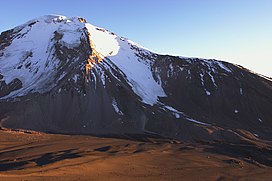
 Pomerape and the saddle below, as seen from south (Parinacota slopes) Pomerape and the saddle below, as seen from south (Parinacota slopes) | |
| Highest point | |
| Elevation | 6,282 m (20,610 ft) |
| Coordinates | 18°07′33″S 69°07′39″W / 18.12583°S 69.12750°W / -18.12583; -69.12750 |
| Geography | |
 | |
| Parent range | Andes |
| Geology | |
| Rock age | Pleistocene |
| Mountain type | Stratovolcano |
| Climbing | |
| Easiest route | snow/ice climb |
Pomerape is a stratovolcano lying on the border of northern Chile and Bolivia (Oruro Department, Sajama Province, Curahuara de Carangas Municipality). It is part of the Payachata complex of volcanoes, together with Parinacota Volcano to the south. The name "Payachata" means "twins" and refers to their appearance. It hosts glaciers down to elevations of 5,300–5,800 metres (17,400–19,000 ft), lower on the northern slope.
Pomerape is a complex of lava domes, accompanied by lava flows which were emplaced atop of the domes. It was active about 200,000 years ago. The lava domes formed first and were later buried by the actual volcanic cone, which unlike the rhyolitic-dacitic domes is formed by hornblende andesite. The "Chungará Andesites" and lava dome complex of Parinacota were laid down at this time. Pomerape is associated with an adventive vent that has erupted mafic magmas. The main cone was last active 106,000 +- 7,000 years ago, the adventive vent is dated to 205,000 ± 24,000 years ago.
Climbing the volcano is alpine grade PD by the east ridge. Harder routes exist on the south face, sometimes on 50+ degree snow/rubble slope. For these routes a camp can be established at 5,300 metres (17,390 ft) at the saddle between Parinacota and Pomerape. Depending on the season, the main difficulty can be penitentes (tall ice-blade needles), which make the ascent physically difficult or impossible.
See also
References
- Chilean IGM elevation Archived 2007-09-27 at the Wayback Machine
- Map of Curahuara de Carangas Municipality and population data. Archived 2014-11-11 at the Wayback Machine
- Schull, William J. (1990). "Introduction: The Place and the Study". In Schull, William J.; Rothhammer, Francisco (eds.). The Aymara. Studies in Human Biology. Vol. 2. Springer Netherlands. pp. 1–18. doi:10.1007/978-94-009-2141-2_1. ISBN 9789401074636.
- Carrasco, Jorge F.; Osorio, Roberto; Casassa, Gino (2008-07-01). "Secular trend of the equilibrium-line altitude on the western side of the southern Andes, derived from radiosonde and surface observations". Journal of Glaciology. 54 (186): 545. Bibcode:2008JGlac..54..538C. doi:10.3189/002214308785837002.
- Gonzalez-Ferran, Oscar (1994). Volcanes de Chile (in Spanish) (1st ed.). Santiago, Chile: Instituto geografico militar. p. 113. ISBN 9789562020541.
- Wörner, Gerhard; Moorbath, Stephen; Horn, Susanne; Entenmann, Jürgen; Harmon, Russel S.; Davidson, Jon P.; Lopez-Escobar, Leopoldo (1994). Reutter, Professor Dr Klaus-Joachim; Scheuber, Dr Ekkehard; Wigger, Dr Peter J. (eds.). Tectonics of the Southern Central Andes. Springer Berlin Heidelberg. p. 81. doi:10.1007/978-3-642-77353-2_5. ISBN 9783642773556.
- Wörner, G.; Harmon, R. S.; Davidson, J.; Moorbath, S.; Turner, D. L.; McMillan, N.; Nyes, C.; Lopez-Escobar, L.; Moreno, H. (1988-09-01). "The Nevados de Payachata volcanic region (18°S/69°W, N. Chile)" (PDF). Bulletin of Volcanology. 50 (5): 287–303. Bibcode:1988BVol...50..287W. doi:10.1007/BF01073587. hdl:2027.42/47805. ISSN 0258-8900. S2CID 129099050.
- Hora, J. M.; Singer, B. S.; Worner, G. (2007). "Volcano evolution and eruptive flux on the thick crust of the Andean Central Volcanic Zone: 40Ar/39Ar constraints from Volcan Parinacota, Chile". Geological Society of America Bulletin. 119 (3–4): 343–362. Bibcode:2007GSAB..119..343H. doi:10.1130/b25954.1.
- Wörner, Gerhard; Hammerschmidt, Konrad; Henjes-Kunst, Friedhelm; Lezaun, Judith; Wilke, Hans (2000-12-01). "Geochronology (40Ar/39Ar, K-Ar and He-exposure ages) of Cenozoic magmatic rocks from Northern Chile (18-22°S): implications for magmatism and tectonic evolution of the central Andes". Revista Geológica de Chile. 27 (2): 205–240. ISSN 0716-0208.
- Gonzalez-Ferran, Oscar (1994). Volcanes de Chile (1st ed.). Santiago, Chile: Instituto geografico militar. p. 113. ISBN 9789562020541.
- Biggar, John (2020). The Andes - A Guide for Climbers and Skiers (5th ed.). Scotland: Andes. p. 192. ISBN 978-0-9536087-6-8.
- "Parinacota". Global Volcanism Program. Smithsonian Institution. (includes Pomerape)
This Oruro Department location article is a stub. You can help Misplaced Pages by expanding it. |
This Arica y Parinacota Region location article is a stub. You can help Misplaced Pages by expanding it. |
This South America mountain, mountain range, or peak related article is a stub. You can help Misplaced Pages by expanding it. |
- Volcanoes of Arica y Parinacota Region
- Stratovolcanoes of Chile
- Subduction volcanoes
- Volcanoes of Oruro Department
- Mountains of Arica y Parinacota Region
- Pleistocene stratovolcanoes
- Polygenetic volcanoes
- Dormant volcanoes
- Bolivia–Chile border
- International mountains of South America
- Six-thousanders of the Andes
- Oruro Department geography stubs
- Chile geography stubs
- South America mountain stubs