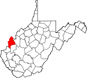
Unincorporated community in West Virginia, United States
| Pondlick, West Virginia | |
|---|---|
| Unincorporated community | |
  | |
| Coordinates: 38°42′49″N 82°06′42″W / 38.71361°N 82.11167°W / 38.71361; -82.11167 | |
| Country | United States |
| State | West Virginia |
| County | Mason |
| Elevation | 610 ft (190 m) |
| Time zone | UTC-5 (Eastern (EST)) |
| • Summer (DST) | UTC-4 (EDT) |
| Area code(s) | 304 & 681 |
| GNIS feature ID | 1560292 |
Pondlick is an unincorporated community in Mason County, West Virginia, United States. Pondlick is located at the junction of County Routes 54 and 56, 9.1 miles (14.6 km) south of Point Pleasant. The community once had a post office, which is now closed.
References
- "Pondlick". Geographic Names Information System. United States Geological Survey, United States Department of the Interior.
- Mason County, West Virginia General Highway Map (PDF) (Map). West Virginia Department of Transportation. 2011. p. 2. Retrieved February 17, 2013.
- "Pondlick Post Office (historical)". Geographic Names Information System. United States Geological Survey, United States Department of the Interior.
| Municipalities and communities of Mason County, West Virginia, United States | ||
|---|---|---|
| County seat: Point Pleasant | ||
| City |  | |
| Towns | ||
| Magisterial districts | ||
| CDPs | ||
| Unincorporated communities |
| |
This article about a location in Mason County, West Virginia is a stub. You can help Misplaced Pages by expanding it. |