| Pont Saint-Michel | |
|---|---|
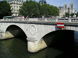
 Pont Saint-Michel with Notre-Dame de Paris in the background Pont Saint-Michel with Notre-Dame de Paris in the background | |
| Coordinates | 48°51′15″N 02°20′41″E / 48.85417°N 2.34472°E / 48.85417; 2.34472 |
| Carries | rue Saint-Denis |
| Crosses | River Seine |
| Locale | Paris, France |
| Next upstream | Petit-Pont |
| Next downstream | Pont Neuf |
| Characteristics | |
| Design | Arch bridge |
| Total length | 62 metres (203 ft) |
| Width | 30 metres (98 ft) |
| History | |
| Designer | Vaudrey, de Lagalisserie, Audrand, Rosier |
| Opened | 1857 |
| Location | |
Pont Saint-Michel (French pronunciation: [pɔ̃ sɛ̃ miʃɛl]) is a bridge linking the Place Saint-Michel on the left bank of the river Seine to the Île de la Cité. It was named after the nearby chapel of Saint-Michel. It is near Sainte Chapelle and the Palais de Justice. The present 62-metre-long bridge dates to 1857.
History
First constructed in 1378, it has been rebuilt several times, most recently in 1857.
The medieval bridge
The construction of a stone bridge was decided upon in 1378 by the Parlement of Paris after an accord with the chapter of the cathedral of Notre-Dame de Paris, the provost of Paris, and the city's merchants. A location downstream of Petit-Pont was chosen, on the line of Rue Saint-Denis, from the Grand-Pont on the right bank and of Rue de la Harpe on the left bank. This allowed for a direct route across Île de la Cité.
The provost, Hugues Aubriot, was charged with overseeing the project, which was funded by the king. Construction lasted from 1379 to 1387. Once complete, the Parisians named the bridge Pont-Neuf (New Bridge, but it should not be confused with the present-day Pont-Neuf), Petit-Pont-Neuf (Little New Bridge) or Pont Saint-Michel dit le Pont-Neuf (St. Michael's Bridge, known as the 'New' Bridge).
As was common in the Middle Ages, the bridge's sides were quickly filled with houses. During the 1407–1408 winter, one of the longest and most severe known in the Middle Ages, ice carried by the frozen Seine hit the bridge, causing it to collapse, together with its houses. Due to France's difficulties in the Hundred Years' War, the bridge was immediately rebuilt in wood. This material proved less resistant than the previous stone bridge and the Parlement of Paris decided in 1444 to allocate all money raised from fines to building a new stone bridge on the site.

The appearance of this second bridge is known from one miniature painting in the Hours of Étienne Chevalier, painted by Jean Fouquet. This shows a bridge resting on high wooden piers, as well as wattle-and-daub or wood-and-plaster houses with a single level roofline along the whole length of the bridge.
The Renaissance bridge


A replacement bridge was built at the same time the Pont Marie was under construction. Owned by the king, it was more substantial than the Pont Marie and never ran into the kind of structural troubles both the Pont Marie and the Pont Neuf encountered.
The work started in 1617 and was completed in 1623, using foundations similar to the ones used in the Rialto Bridge and the Pont des Boucheries. These foundations used wooden piles topped by a wooden platform over which the specifications required lower stone courses of 5 feet (1.5 m) to 6 feet (1.8 m) long by 3 feet (0.91 m) to 4 feet (1.2 m) thick.
Built with four spans in the form of circular arcs, the roadway sloped up to the center of the bridge with a grade of over 6%. The two larger spans were approximately 46 feet (14 m) long, while the two shorter spans, on either side, were approximately 33 feet (10 m) long. The widest of the old Paris bridges, it was designed to hold two rows of houses. An order was issued in 1786 to remove all houses from Paris bridges, but the ones on this bridge remained until 1808.
The modern bridge

The present 62-metre-long bridge dates to 1857, requiring only seven months for construction, from the date the older bridge was closed to traffic, and was designed on three 17.2m arches by Paul-Martin Gallocher de Lagalisserie and Paul Vaudrey. It was the site of many of the killings of protesters by the police, in the Paris massacre of 1961, and a commemoration plaque on the bridge was unveiled by the mayor of Paris in 2001.
Location

The entrances to two underground stations are located next to the bridge in Place Saint-Michel. Saint-Michel is on line 4 of the Paris Métro, whilst Saint-Michel-Notre-Dame is on line B and line C of the Paris Réseau Express Régional (RER).
Gallery
-
 View from Petit-Pont
-
 View from Petit-Pont
Bibliography
- (in French) P. Lorentz et D. Sandron, Atlas de Paris au Moyen Âge, Paris, 2006, Parigramme.
References
- ^ Whitney, Charles S. (2003) . Bridges of the World: Their Design and Construction. Mineola, New York: Dover Publications. pp. 143–144. ISBN 0-486-42995-4.
- "Saint-Michel Notre-Dame". Transilien. Retrieved 19 April 2023.
External links
- (in French) Mairie de Paris site
- (in French) Structurae
- Satellite view on Google Map
- Pont Saint-Michel at Structurae (1378–1387)
- Pont Saint-Michel at Structurae (1416)
- Pont Saint-Michel at Structurae (1549)
- Pont Saint-Michel at Structurae (1618–1624)
- Pont Saint-Michel at Structurae (current)
- Bridges over the River Seine in Paris
- Bridges completed in 1857
- Buildings and structures in the 1st arrondissement of Paris
- Buildings and structures in the 4th arrondissement of Paris
- Buildings and structures in the 5th arrondissement of Paris
- Buildings and structures in the 6th arrondissement of Paris
- 1857 establishments in France