Suburb of Charters Towers, Queensland, Australia
| Queenton Charters Towers, Queensland | |||||||||||||||
|---|---|---|---|---|---|---|---|---|---|---|---|---|---|---|---|
 Bushland, Queenton, 2013 Bushland, Queenton, 2013 | |||||||||||||||
 | |||||||||||||||
| Coordinates | 20°04′34″S 146°16′53″E / 20.0761°S 146.2813°E / -20.0761; 146.2813 (Queenton (centre of suburb)) | ||||||||||||||
| Population | 1,236 (2021 census) | ||||||||||||||
| • Density | 228.9/km (593/sq mi) | ||||||||||||||
| Postcode(s) | 4820 | ||||||||||||||
| Area | 5.4 km (2.1 sq mi) | ||||||||||||||
| Time zone | AEST (UTC+10:00) | ||||||||||||||
| Location |
| ||||||||||||||
| LGA(s) | Charters Towers Region | ||||||||||||||
| State electorate(s) | Traeger | ||||||||||||||
| Federal division(s) | Kennedy | ||||||||||||||
| |||||||||||||||
Queenton is an eastern suburb of Charters Towers in the Charters Towers Region, Queensland, Australia. In the 2021 census, Queenton had a population of 1,236 people.
Geography

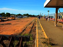
The Great Northern railway passes through Queenton from the north-east to the south-west with Charters Towers railway station, also known as the Queenton railway station, (20°04′38″S 146°16′15″E / 20.0772°S 146.2709°E / -20.0772; 146.2709 (Charters Towers railway station)) within the locality. The railway line forms both part of the locality's north-eastern boundary and also part of its western boundary. The Flinders Highway forms a part of the locality's eastern boundary.
The land is predominantly flat (approximately 300 metres above sea level), partly residential, partly old mine ruins, and partly undeveloped bushland.
History

Over 5,000 people were buried in the Pioneer Cemetery from 1872 to 1895.
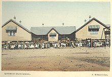
Queenton State School opened on 13 July 1891 and closed on 1 September 1931.
Charters Towers Mental Hospital (also known as Mosman Hall Special Hospital) opened on 1 July 1954 with the first patients admitted on 16 September 1954, having been transferred from the Brisbane Mental Hospital and Toowoomba Mental Hospital. The facility was named after Hugh Mosman, who found gold at Charters Towers.It was operated by the Queensland Government at 35 Gladstone Road (20°04′36″S 146°16′51″E / 20.0768°S 146.2807°E / -20.0768; 146.2807 (MOSMAN HALL SPECIAL HOSPITAL)). The hospital closed circa 2001. It was replaced on the site by a new mental health facility, the Charters Towers Rehabilitation Unit, at the front of the site and the Kernow master-planned residential community and hotel at the rear of the site.
Tors Drive-In Cinema opened in 1966.
On 3 August 2012, a part of Queenton was excised and made part of the new suburb of Charters Towers City.
Demographics
In the 2011 census, Queenton had a population of 1,702 people.
In the 2016 census, Queenton had a population of 1,285 people.
In the 2021 census, Queenton had a population of 1,236 people.
Heritage listings
Queenton has a number of heritage-listed sites, including:
- Signals, Crane and Subway, Charters Towers Railway Station, Enterprise Road
- Charters Towers mine shafts
- Stone kerbing, channels and footbridges of Charters Towers
Education
There are no schools in Queenton. The nearest government primary schools are Millchester State School in neighbouring Millchester to the south, Charters Tower Central State School in neighbouring Charters Towers City to the west, and Richmond Hill State School in neighbouring Richmond Hill to the north. The nearest government secondary school is Charters Towers State High School in Charters Towers City.
Amenities
Charters Towers Indoor Sports Centre is at 11-17 New Queen Road (20°04′21″S 146°16′24″E / 20.0726°S 146.2733°E / -20.0726; 146.2733 (CHARTERS TOWERS INDOOR SPORT CENTRE)). It provides a variety of sports in an indoor setting including netball, cricket, volleyball and soccer.
Charters Towers Tors Drive-in Cinema is an outdoor movie theatre at 110-120 New Queen Road (20°03′54″S 146°17′27″E / 20.0650°S 146.2907°E / -20.0650; 146.2907 (CHARTERS TOWERS TORS DRIVE IN)). It is the oldest continuously-operating drive-in theatre in Queensland.
Facilities
Charters Towers Rehabilitation Unit is a residential facility for people with complex mental health needs at 35 Gladstone Road (20°04′35″S 146°16′51″E / 20.0764°S 146.2808°E / -20.0764; 146.2808 (health centre)).
Charters Towers Pioneer Cemetery is on a block bounded by North, South, East and West Streets (20°05′08″S 146°16′11″E / 20.0856°S 146.2697°E / -20.0856; 146.2697 (Pioneer Cemetery-Charters Towers)).
References
- ^ Australian Bureau of Statistics (28 June 2022). "Queenton (SAL)". 2021 Census QuickStats. Retrieved 28 February 2023.

- ^ "Queenton – suburb in Charters Towers Region (entry 49632)". Queensland Place Names. Queensland Government. Retrieved 27 December 2020.
- "Railway stations and sidings - Queensland". Queensland Open Data. Queensland Government. 2 October 2020. Archived from the original on 5 October 2020. Retrieved 5 October 2020.
- "Charters Towers – railway station in Charters Towers Region (entry 6947)". Queensland Place Names. Queensland Government. Retrieved 7 March 2021.
- ^ "Queensland Globe". State of Queensland. Retrieved 7 March 2021.
- "Pioneer Cemetery". Tourism & Events Queensland. Queensland Government. Archived from the original on 3 May 2024. Retrieved 3 May 2024.
- "Pioneer Cemetery". Visit Charters Towers. Archived from the original on 18 March 2024. Retrieved 3 May 2024.
- "Agency ID 9190, Queenton State School". Queensland State Archives. Retrieved 1 August 2017.
- "Mental hospital at Charters Towers satisfies great need". Townsville Daily Bulletin. Vol. LXXIV. Queensland, Australia. 1 July 1954. p. 2. Archived from the original on 3 May 2024. Retrieved 3 May 2024 – via National Library of Australia.
- "First Patients On Thursday". The Northern Miner. Queensland, Australia. 14 September 1954. p. 1. Archived from the original on 3 May 2024. Retrieved 3 May 2024 – via National Library of Australia.
- "Transfer of mental patients". Brisbane Telegraph. Queensland, Australia. 14 September 1954. p. 6 (CITY FINAL). Archived from the original on 3 May 2024. Retrieved 3 May 2024 – via National Library of Australia.
- ^ "Building areas - Queensland". Queensland Open Data. Queensland Government. 17 November 2020. Archived from the original on 23 October 2020. Retrieved 17 November 2020.
- "Charters Towers Mental Hospital (1954 - c. 2001)". Find & Connect. Australian Government. Archived from the original on 23 March 2024. Retrieved 3 May 2024.
- "Mental asylum becomes residential community". Realestate.com.au. 21 March 2017. Archived from the original on 7 November 2022. Retrieved 3 May 2024.
- "About Kernow | Kernow Charters Towers". Archived from the original on 13 March 2024. Retrieved 3 May 2024.
- Brown, Trudy (10 November 2020). "You'd have to be mental not to stay at this unique NQ hotel". Townsville Bulletin. Archived from the original on 3 May 2024. Retrieved 3 May 2024.
- ^ "Tors Drive-In Cinema located in Charters Towers, Queensland". www.torsdrive-in.com. Archived from the original on 3 May 2024. Retrieved 3 May 2024.
- Australian Bureau of Statistics (31 October 2012). "Queenton (SSC)". 2011 Census QuickStats. Retrieved 21 June 2016.

- Australian Bureau of Statistics (27 June 2017). "Queenton (SSC)". 2016 Census QuickStats. Retrieved 20 October 2018.

- "Signals, Crane and Subway, Charters Towers Railway Station (entry 602627)". Queensland Heritage Register. Queensland Heritage Council. Retrieved 7 July 2013.
- "Charters Towers Gold Mine Shafts and Remains (entry 602221)". Queensland Heritage Register. Queensland Heritage Council. Retrieved 7 July 2013.
- "Stone kerbing, channels and footbridges of Charters Towers (entry 602512)". Queensland Heritage Register. Queensland Heritage Council. Retrieved 7 July 2013.
- "Charters Towers Indoor Sports". Charters Towers Regional Council. Archived from the original on 6 April 2024. Retrieved 3 May 2024.
- "Building points - Queensland". Queensland Open Data. Queensland Government. 17 November 2020. Archived from the original on 25 November 2020. Retrieved 25 November 2020.
- Ogborne, Carly (9 February 2020). "Where Can You See a Drive-In Movie in Queensland". Weekend Notes. Archived from the original on 9 February 2023. Retrieved 3 May 2024.
- "Landmark Areas - Queensland". Queensland Open Data. Queensland Government. 18 November 2020. Archived from the original on 21 November 2020. Retrieved 21 October 2020.
- "Charters Towers Rehabilitation Unit". Townsville Hospital and Health Service. Archived from the original on 8 March 2020. Retrieved 3 May 2024.
- "Cemetery Areas - Queensland". Queensland Open Data. Queensland Government. 12 November 2020. Archived from the original on 15 November 2020. Retrieved 12 November 2020.
External links
- "Charters Towers Suburbs". Queensland Places. Centre for the Government of Queensland, University of Queensland. Retrieved 15 October 2017.