| This article needs additional citations for verification. Please help improve this article by adding citations to reliable sources. Unsourced material may be challenged and removed. Find sources: "Quezaltepeque, El Salvador" – news · newspapers · books · scholar · JSTOR (July 2023) (Learn how and when to remove this message) |
| Quezaltepeque | |
|---|---|
| Municipality | |
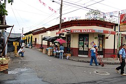
 Street corner in Quezaltepeque Street corner in Quezaltepeque | |
 Flag Flag | |
 | |
| Coordinates: 13°50′N 89°16′W / 13.833°N 89.267°W / 13.833; -89.267 | |
| Country | El Salvador |
| Department | La Libertad |
| Elevation | 1,401 ft (427 m) |
Quezaltepeque is a municipality in the La Libertad department of El Salvador.
It is located about 15 km from San Salvador.
The word Quezaltepeque is a Nahuat word meaning "hills of quetzal." A quetzal is a bird that used to live around the area of Quezaltepeque. High levels of deforestation forced the bird to migrate to other areas.
People
- Darwin Cerén (born 1989), Salvadoran footballer who plays for C.D Águilla and the El Salvador national football team
- Manuel Flores Cornejo (born 1965), Farabundo Martí National Liberation Front (FMLN) 2024 presidential candidate
- Alfonso Quijada Urías (born 1940), poet
- Salvador Sánchez Cerén (born 1944), president of El Salvador (2014–2019)
Sports
The local football club is named Juventud Alegre F.C. and it currently plays in the Salvadoran Third Division.
References
- "Quezaltepeque, El Lugar Donde Nací" [Quezaltepeque, The Place I Was Born]. Manuel El Chino Flores.com (in Spanish). 1 April 2018. Archived from the original on 16 August 2018. Retrieved 10 July 2023.
| Capital: Santa Tecla | ||
| Districts |  | |
| Geography | ||
| Landmarks | ||
This El Salvador location article is a stub. You can help Misplaced Pages by expanding it. |