"Rapaki" redirects here. For the floating crane, see Rapaki (steam crane).

Te Rāpaki-o-Te Rakiwhakaputa, commonly known as Rāpaki or Rapaki, is a small settlement within the Lyttelton Harbour basin.
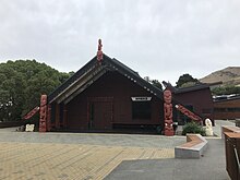
Rāpaki is one of four Banks Peninsula rūnanga (communities) based around marae (tribal meeting grounds). The Rāpaki Marae, also known as Te Wheke Marae, is a meeting ground of Ngāi Tahu and its Hapū o Ngāti Wheke branch. Its wharenui (meeting house), called Te Wheke, opened in 2008, was carved by Riki Manuel and Fayne Robinson, with tukutuku panels overseen by local weaver 'Aunty' Doe Parata. The carvings of the wharenui trace the almost 400 years of continuous settlement related to the arrival of the ancestor Te Rakiwhakaputa.

Rāpaki is overlooked by the peak Te Poho o Tamatea. According to one legend, the Ngāi Tahu chief Te Rakiwhakaputa named the place by laying his waist mat (rāpaki) down to claim it. The full name of Rāpaki is Te Rāpaki-o-Te Rakiwhakaputa, meaning the waist mat of Te Rakiwhakaputa. On 8 July 2020, the New Zealand Geographic Board assigned the full name as the official name of the locality.
References
- Wilson, John. "Canterbury places – Lyttelton Harbour". Te Ara: The Encyclopedia of New Zealand. Retrieved 14 July 2020.
- ^ "Te Hapū o Ngāti Wheke". Te Rūnanga o Ngāi Tahu. Retrieved 14 July 2020.
- "Te Kāhui Māngai directory". tkm.govt.nz. Te Puni Kōkiri.
- "Māori Maps". maorimaps.com. Te Potiki National Trust.
- ^ "Te Wheke to be reborn at Rapaki Marae". Stuff. 23 July 2009. Retrieved 17 January 2023.
- Rapaki marae introduction
- "Notice of the Final Determinations of the Minister for Land Information on Official Geographic Names". New Zealand Gazette. New Zealand Government. Retrieved 10 July 2020.
43°36′14″S 172°40′46″E / 43.6040°S 172.6795°E / -43.6040; 172.6795
This Canterbury Region-related geography article is a stub. You can help Misplaced Pages by expanding it. |