| Scald Law | |
|---|---|
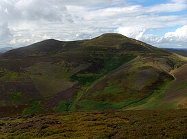
 Scald Law as seen from the northeast Scald Law as seen from the northeast | |
| Highest point | |
| Elevation | 579 m (1,900 ft) |
| Prominence | c. 312 metres (1,024 ft) |
| Listing | Marilyn, Hardy |
| Coordinates | 55°50′09″N 3°17′24″W / 55.8357°N 3.2901°W / 55.8357; -3.2901 |
| Geography | |
| Location | Midlothian, Scotland |
| OS grid | NT191610 |
| Topo map | OS Landranger 65 |
| Climbing | |
| Easiest route | Hike |
Scald Law is a hill in Midlothian, Scotland. At 579 metres (1,900 ft) it is the highest of the Pentland Hills. The hill is composed of Devonian volcanic rock.
Etymology
The origin of the name is uncertain. Some sources say it derives from the Scots word scawed, meaning "bare." Another explanation is that it derives from scaldberry, an old name for blackberry. The word law is derived from the Old English for hill.
References
- Glossary of Scots origins of place names in Britain (N to Y)
- "Archived copy". Archived from the original on 21 February 2007. Retrieved 14 March 2007.
{{cite web}}: CS1 maint: archived copy as title (link) - Dixon, Norman (1947). The Placenames of Midlothian (PDF) (Thesis). University of Edinburgh. pp. 27, 45, 46, 240. Retrieved 13 September 2021.
External links
 Media related to Scald Law at Wikimedia Commons
This Midlothian location article is a stub. You can help Misplaced Pages by expanding it. |