| Sinda District | |
|---|---|
| District | |
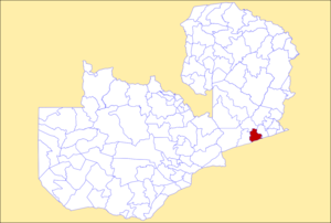
 District location in Zambia District location in Zambia | |
| Country | |
| Province | Eastern Province |
| Area | |
| • Total | 2,620.6 km (1,011.8 sq mi) |
| Population | |
| • Total | 213,762 |
| • Density | 82/km (210/sq mi) |
| Time zone | UTC+2 (CAT) |
The Sinda District is a district of Zambia, located in the Eastern Province. It was created in 2012 by taking part of Petauke District and part of Katete District. It consists of two constituencies, namely Sinda and Kapoche. As of the 2022 Zambian Census, the district had a population of 161,595 people.
References
- ^ About Sinda - Sinda Town Council
- ^ zamobserver (2022-11-01). "K900,000 DISBURSED TO DIFFERENT GROUPS IN SINDA DISTRICT, EASTERN PROVINCE UNDER THE CDF | The Zambian Observer". Retrieved 2024-08-22.
- Government Gazette Notice
- "Sinda Buys 12,000 desks using CDF". Zambia24. 19 February 2024. Retrieved 22 August 2024.
- 2022 Census of Population and Housing - Preliminary Report (PDF)
| Central Province | |
|---|---|
| Copperbelt Province | |
| Eastern Province | |
| Luapula Province | |
| Lusaka Province | |
| Muchinga Province | |
| Northern Province | |
| North-Western Province | |
| Southern Province | |
| Western Province | |
14°14′S 31°43′E / 14.233°S 31.717°E / -14.233; 31.717
This Zambia location article is a stub. You can help Misplaced Pages by expanding it. |