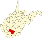
Unincorporated community and census-designated place in West Virginia, United States
| Sprague, West Virginia | |
|---|---|
| Unincorporated community and census-designated place | |
  | |
| Coordinates: 37°47′38″N 81°10′56″W / 37.79389°N 81.18222°W / 37.79389; -81.18222 | |
| Country | United States |
| State | West Virginia |
| County | Raleigh |
| Elevation | 2,392 ft (729 m) |
| Time zone | UTC-5 (Eastern (EST)) |
| • Summer (DST) | UTC-4 (EDT) |
| ZIP code | 25926 |
| Area code(s) | 304 & 681 |
| GNIS feature ID | 2807508 |
Sprague is an unincorporated community and coal town in Raleigh County, West Virginia, United States. Sprague is located on West Virginia Route 16, 1 mile (1.6 km) north of downtown Beckley. Sprague has a post office with ZIP code 25926.
The community was named in 1902.
Climate
The climate in this area has mild differences between highs and lows, and there is adequate rainfall year-round. According to the Köppen Climate Classification system, Sprague has a marine west coast climate, abbreviated "Cfb" on climate maps.
References
- ^ U.S. Geological Survey Geographic Names Information System: Sprague, West Virginia
- ZIP Code Lookup
- Kenny, Hamill (1945). West Virginia Place Names: Their Origin and Meaning, Including the Nomenclature of the Streams and Mountains. Piedmont, WV: The Place Name Press. p. 595.
- Climate Summary for Sprague, West Virginia
This article about a location in Raleigh County, West Virginia is a stub. You can help Misplaced Pages by expanding it. |
