| Three Brothers | |
|---|---|
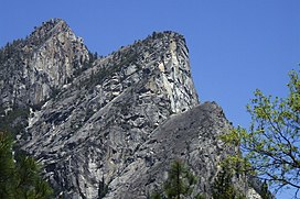
 Three Brothers as seen from Valley Loop trail Three Brothers as seen from Valley Loop trail | |
| Highest point | |
| Elevation | 7,783 ft (2,372 m) NAVD 88 |
| Prominence | 379 ft (116 m) |
| Coordinates | 37°44′46″N 119°36′53″W / 37.7460126°N 119.614712°W / 37.7460126; -119.614712 |
| Geography | |
  | |
| Location | Yosemite National Park, Mariposa County, California, United States |
| Parent range | Sierra Nevada |
| Topo map | USGS Half Dome |
| Geology | |
| Rock age | Cretaceous |
| Mountain type | granite rock |
The Three Brothers is a rock formation in Yosemite Valley, California. It is located just east of El Capitan and consists of Eagle Peak (the uppermost "brother"), and Middle and Lower Brothers.
The name Three Brothers
Members of the Mariposa Battalion named the Three Brothers after the capture of the three sons of Chief Tenaya near the base of the Three Brothers.
Their original name
The Ahwahnechee name was "Kom-po-pai-zes", or sometimes "Pompomposus", is translated as "mountains with heads like frogs when ready to leap".
John Muir
John Muir considered the view from Eagle Peak to be the most beautiful view of Yosemite Valley available.
References
- ^ "Eagle". NGS Data Sheet. National Geodetic Survey, National Oceanic and Atmospheric Administration, United States Department of Commerce. Retrieved 2014-01-20.
- "Eagle Peak". Peakbagger.com. Retrieved 2014-01-20.
- "Rock Formations in Yosemite Valley". Yosemite National Park, National Park Service.
- ^ Richard J. Hartesveldt (1955). "Yosemite Valley Place Names". Yosemite Natural History Association. Retrieved 3 September 2017.
External links
- "Eagle Peak (Yosemite)". SummitPost.org.
This Yosemite-related article is a stub. You can help Misplaced Pages by expanding it. |
This Mariposa County, California–related article is a stub. You can help Misplaced Pages by expanding it. |