| Tullich Hill | |
|---|---|
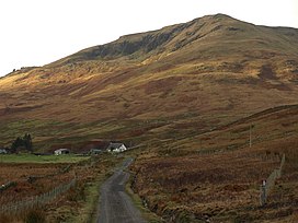
 Tullich Hill from Glen Douglas Tullich Hill from Glen Douglas | |
| Highest point | |
| Elevation | 632 m (2,073 ft) |
| Prominence | 273 m (896 ft) |
| Listing | Graham, Marilyn |
| Coordinates | 56°10′04″N 4°45′00″W / 56.1678°N 4.7499°W / 56.1678; -4.7499 |
| Geography | |
| Location | Argyll and Bute, Scotland |
| Parent range | Grampian Mountains |
| OS grid | NN293006 |
| Topo map | OS Landranger 56 |
Tullich Hill (632 m) is a hill in the southern Grampian Mountains of Scotland. It lies south of the village of Arrochar, between Loch Long and Loch Lomond in Argyll.
An irregular, rocky hill, its most distinguished feature is the corrie on its southern slopes.
References
- "Tullich Hill". hill-bagging.co.uk. Retrieved 23 October 2019.
- "walkhighlands Tullich Hill". walkhighlands.co.uk. Retrieved 23 October 2019.
This Scottish location article is a stub. You can help Misplaced Pages by expanding it. |