| Voisenon | |
|---|---|
| Commune | |
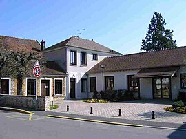
 The town hall in Voisenon The town hall in Voisenon | |
| Location of Voisenon | |
  | |
| Coordinates: 48°34′16″N 2°39′53″E / 48.5712°N 2.6647°E / 48.5712; 2.6647 | |
| Country | France |
| Region | Île-de-France |
| Department | Seine-et-Marne |
| Arrondissement | Melun |
| Canton | Melun |
| Intercommunality | Melun Val de Seine |
| Government | |
| • Mayor (2020–2026) | Julien Aguin |
| Area | 3.36 km (1.30 sq mi) |
| Population | 1,169 |
| • Density | 350/km (900/sq mi) |
| Time zone | UTC+01:00 (CET) |
| • Summer (DST) | UTC+02:00 (CEST) |
| INSEE/Postal code | 77528 /77950 |
| Elevation | 69–96 m (226–315 ft) |
| French Land Register data, which excludes lakes, ponds, glaciers > 1 km (0.386 sq mi or 247 acres) and river estuaries. | |
Voisenon (French pronunciation: [vwaznɔ̃] ) is a commune in the Seine-et-Marne department, in the Île-de-France region in north-central France.
A little village, located 39 kilometres south-east from the center of Paris, Voisenon was mainly known for its 12th century abbey, and then for its renowned local figure, Claude-Henri de Fusée de Voisenon, academician and abbot. Still dedicated to cereal growing, it now enjoys the advantages of its nearest city, Melun, while keeping a country-style atmosphere.
Inhabitants of Voisenon are called Voisenonais.
History
Origins
The etymology is likely to indicate a Gaulish presence, but no evidence of this has been found yet.
Fief and earldom
The first mention of the place appears in the 12th century. During the Middle Ages, Voisenon was the Fusée family's fief and was attached to the crown lands of France.
The fall
The Fusée lost the estate in 1790 and 1791.
Contemporary
In 1949, the Château du Jard was given to the Association des paralysés de France, and used as a vocational school for persons with motor disability.
Demographics
In 2007, a total of 1,108 inhabitants lived in Voisenon, according to the official census.
Transport
The nearest railway station is Melun station, which is an interchange station on Paris RER line D, on the Transilien R suburban rail line, and on several national rail lines. It is located 27 kilometres from Paris-Orly Airport, and 50 kilometres from Paris-Charles de Gaulle Airport.
See also
References
- "Répertoire national des élus: les maires". data.gouv.fr, Plateforme ouverte des données publiques françaises (in French). 9 August 2021.
- "Populations de référence 2022" (in French). The National Institute of Statistics and Economic Studies. 19 December 2024.
External links
- Official site (in French)
- Base Mérimée: Search for heritage in the commune, Ministère français de la Culture. (in French)
This article related to a Seine-et-Marne location is a stub. You can help Misplaced Pages by expanding it. |